Girls in Glacier | WELCOME
Like us on Facebook
  • Home
  • About
  • Calendar
  • Blog
  • Flowers/Trees
  • Helpers
  • Goodbye
  • HIkes
    • Hikes 2023
    • Hikes 2022
    • Hikes 2021
    • Hikes 2020
    • Hikes 2019
    • Hikes 2018
    • Hikes 2017
    • Hikes 2016
    • Hikes 2015
    • Hikes 2014
    • Hikes 2013
    • Hikes 2012

Muddy Creek Falls, July 12, 2021

7/13/2021

0 Comments


Cool Canyon with Waterfall Beckons Gals on Hot Weather Streak

Picture
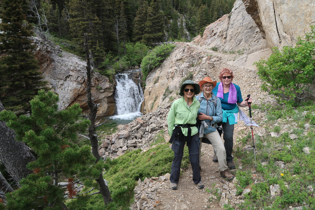
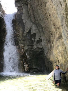
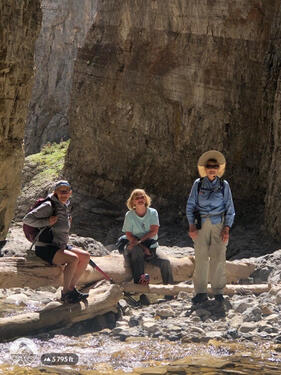
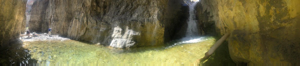
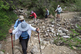
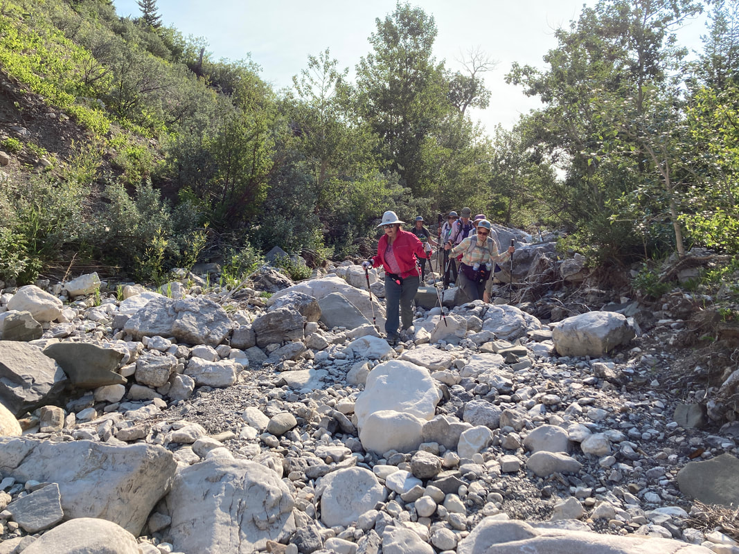
One-hundred-degree weather hit Great Falls and then never let up for three weeks, prompting several trip cancellations, including a substitution this week: Blackleaf Canyon, which is exposed with lots of uphill, to Muddy Creek Falls, which is much shorter and flat, although it is an obstacle course. And the fires were blazing creating smoke. We figured a canyon hike would be better than a view hike, as our views would be occluded with smoke.

We left Great Falls at 5:30 a.m., thinking we would beat the heat of the say, which was predicted to be in the 80s, even in the mountains. After a comfort stop in Choteau, we arrived at the trailhead at 7:45 and hit trail just before 8, after gearing up.

This trail showed its challenged right away with a bushwhack down the two-track road. The silver berry was thick in spots as we made our way to the wash out from the floods of the last few years. To prevent anyone from getting lost or not making our way back to the cars, Katie placed marking tape on several trees at key intersections, although there is no guarantee of coming back the exact same way.  This hike is one that is rarely hiked the same way twice as you just make your way however best you can by following the dry streambed, crossing back and forth as needed.

And the streambed isn't easy to navigate as it has many boulders and large rocks that could turn an ankle if not careful. So we alternated between walking up the streambed and following cattle and game trails through the thick brush and trees on the banks, whichever seemed the easiest in places. 

It wasn't until the last half mile that we came across water and the place that Muddy Creek goes subterranean. At this point, the canyon narrows, which forced us into the water for the last part of our trek.

Still, there wasn't much water in the creek for this time of year, but once we hit the falls, we saw plenty of water. The pool was too deep to approach the falls, and we had to navigate around several boulder areas. It's always a surprise to see this falls for the first time, and it was a first for Maria, Susan and Doreen.

It took us 2 hours and 45 minutes to hike just under 2.5 miles, so it shows you the extent of the trail finding and obstacles, around which we had to negotiate. But it was an adventure. On the way back, Maria, Camille, Doreen took turns leading with Maria doing the lead most of the way, We were able to retrace our steps very well, with Maria and Camille finding some better ways to avoid the boulders in the creek bed.

We arrived back at the cars at 1:30 and drove to Choteau for a comfort stop and ice cream. We arrived home by 4 p.m.
Who went: Susan, Camille, Maria, Randi, Doreen, Bonnie, Katie

Katie & Doreen Pix
Camille Pix
0 Comments

Two Med Waterfalls, July 6, 2021

7/7/2021

0 Comments


GiG Goes to Glacier's Two Med to Escape Extreme Heat

Picture
Facing temps in the high 90s in Great Falls, the GiG decided to find the coolest place around the state, so we could still get a hike in, one without a lot of elevation gain, and Two Medicine Lake fit the bill.  We decided to hike around the lake and go to four waterfalls, so we could tick off a few on our 21 waterfalls goal for the year.

This hike also has several variations, so those who don't want to go as far can ride the boat.  We had one group walk all the way around the lake and to Twin and Aster Falls, one group go over and back on the boat and to both the falls and one group that took the boat halfway and walked the other half around the lake, hitting the falls along the way.  We were able to take 10 gals, with Doreen graciously giving up her boat ticket so Karen could come along.

After the lake hike, we drove to Scenic Point trailhead for Apistoki Falls and then a bit farther down the road to Trick/Running Eagle Falls.

It all started at 5 a.m. as the only boat tickets left by the time we decided on this plan were the 8 a.m. ones. But with the heat predicted to be 78-80 degrees, we were all happy to get an early start.

Nothing too eventful happened on the drive, except Katie had forgotten to fill her water bottles so we had to make an extra stop in Browning to buy some.

We made it to Two Medicine by 7:40, plenty of time to use the facilities and catch the boat. One car dropped off the hikers in the campground before heading for Two Med lake parking lot and the boat dock.

The hikers set a faster pace than normal as they needed to hoof it in order to meet up at Twin Falls with the faster boat. We figured they may need to wait 5-10 minutes even with the faster pace.  On the hike, we only happened upon 4-5 other hikers, so it was a quiet trek. We saw lots of moose poo but no animals; the boat group, on the other hand, saw a moose swimming across the lake! What a sight.

The boat gals arrived about one minute before the hikers, so everything worked out perfectly!  We were all amazed. They said the boat had been redone--over 30,000 man hours, and it looks beautiful. The boat was about 3/4 full, not the half as promised.

There were quite a few people at the falls at first, a result of many others who rode the boat doing it too, but it soon thinned. We took our packs off and had a snack. Then it was time for the boaters to decide if they were hiking around the lake or taking the boat back. All decided to hike except two, who would then hike to Aster Falls after taking the boat back. This option is 1.2 miles shorter and mostly flat. The hikers faced about 400 feet of elevation gain coming up from the boat dock, but this stretch is beautiful with views across the lake and flowers galore in this sunny, open section. In this section, we could shout and wave at those awaiting the boat.

And again, we were amazed that those hike the whole south shore met with those hiking from the boat dock reached Aster Falls within minutes of each other. Everything was working out with no glitches!  There were quite a few people at Aster Falls, so we didn't stay long and opted to hike back to the foot of the lake to have our lunch. This stretch of trail was pretty crowded. We came across numerous hiking groups, as we helped give directions and advice  when asked.

We arrived at the lake at 12:30 and took a half hour to visit the campstore and eat our lunches (they didn't make any of their awesome roasted red pepper gouda cheese soup since it was so hot, which was a disappointment. Some of us would have had soup anyway; it's that good.)

After our break and lunch, we drove to the Scenic Point parking area, which was full. We had to improvise space by the garbage cans. Then all except Gail hiked to Apistoki Falls, Katie taking us the shortcut way.  This hike gets rather steep and has limited views of the falls, but we wanted to check one off the list, which we did. We happened upon a couple who said some sheep were by the falls. We didn't see any; however, the trail on the way down was covered in sheep poo, and lo and behold, the sheep were in the parking area when we got back down. There were several ewes, yearling and two babies from this year. They were right by the cars, a bit too close for comfort; they were bleating and bahing and licking a dark spot on the  ground, which usually means someone urinated there. They like the salt. What a treat to watch them for a while.

Then we did our last hike of the day to Trick/Running Eagle Falls, a short jaunt of 3/4 of a mile to a "double" water falls, one spilling over the other (in early and late season, it is only one falls--it is only double during run-off season). The falls had a bit running over the top but the part out of the cave was rushing.

By now, it was almost 3:30. We decided to opt for eating in Dupuyer instead of East Glacier. We got there just before 5, had a nice meal and got home before 7:30. A great day!

Who went: Gail, Jo Ann, Karen, Randi, Maria, Susan, Sue, Doreen, Bonnie, Katie
Hikers: Doreen, Katie, Susan
Half Boat: Karen, Randi, Sue, Maria, Bonnie
Boat: Gail, Jo Ann

Jo Ann Pix
Katie pix
0 Comments

Fairview Mountain, June 27, 2021

6/28/2021

0 Comments


Perfect Day to Sit on a Mountain Before the Heat Wave Hits

Picture
At 6:30 a.m., with six crammed into Katie's Highlander, we headed to Augusta, not for the rodeo, but for a climb of Fairview Mountain in the Rocky Mountain Front.

The day promised to be a bit of a hot one to do 3,000 feet of uphill, but we hoped our early start would get us to the top before it got roasting, and we were pleasantly surprised that the day never heated too much with a breeze and cloud cover. 

Today was a test for three of us: Katie with her hip and shoulder issues from the car accident still bothering, Amber with Achilles' tendon issues from running and her bad ankle and Susan with ankle and knee issues from her ankle operation four years ago. But we all made it to the top and in pretty good form, albeit hurting at times.

Before our hike started, we spied a doe on the side of a hill nursing her two fawns; she quickly left with the babies boing-boinging up and over the hill. So cute! Then we went through the fence, carefully crossed the stream on some old logs, and hit the trail.

We enjoyed the canyon with the string of waterfalls, checking off Willow Creek Falls and Upper Willow Creek Falls. At times, it was fairly hot with no breeze. We prayed it wouldn't warm up even more. Then we headed for the off-trail portion of the hike, the reason we had Katie's husband Tom along, yet we were able to follow old cow and game trails until the saddle. The trails were more distinct from years past.

From there, the slant got progressively steeper until we reached a second saddle, where it leveled out for a bit before the final ascent over very rocky, steep terrain. On this last stretch, the wind picked up and some ominous clouds hung over us, giving us a bit of a chill.

Once we gained the top, we were surprised at how calm it had become, so we could enjoy the views for a while before descending a bit for a lunch spot as the wind picked up once again. But not before we snapped a few summit pictures and put three rocks on the cairn for the three ladies who have gone before us: Chrissie, Colette/Coco and Phyllis.

We were so lucky to find a day before the heat warning engulfs us later in the week. 

Instead of retracing our steps, we did a lollipop, by creating a loop out of the off-trail scramble, going through some old snags and rock ledges. On this part, we came across different zones of wildflowers, one with forget-me-nots, one with shooting stars, one with arrow-leaf balsamroot.

We got back to the cars at 4:30 to find another vehicle there with a couple from Helena, who had no idea where they really were or how far the falls were. We explained to them about the gorgeous canyon and the falls. They also said they were log-time members of MWA and wondered about the name change to Montana Wild, Camille, being on the board, explained to him the logic.

Then it was back home via Augusta right as the rodeo was ending. We got into a traffic jam getting through the four-block town, taking about 15 mintues as we people watched: cowboys spinning their hats, beers in hand; people lined up for burgers at the Buckhorn Bar and a giant Budweiser bottle blow-up swinging in the breeze.

We arrived home around 6 p.m.
Who went: Camille, Susan, Suzie T, Amber, Katie (Guide Tom)

Pix
Picture
0 Comments

King's Hill, June 25, 2021

6/26/2021

0 Comments


In Pursuit of Limestone Columbine Turns No Luck into Nice Evening

Picture
Six Giggers headed out at 3 p.m. for an evening hike to find the rare limestone or Jones columbine that inhabits alpine rocky peaks. We had seen some before on the top of Kings Hill, they were blooming on other mountains, so hoped to see them again. Alas, after a climb up the jeep road, we were skunked. We saw the leaves but no flowers. We didn't see but one or two seeds, making us think that this year's weird weather, warm, below freezing several days and then over 100 and in the 90s for a week in May might have done them in.

And, indeed, we didn't see many flowers at all. The only prolific flower was white phlox. We saw a few others such as Jacob's ladder and larkspur, but not many of them; such a change from a year ago.

But the evening was so pleasant that we enjoyed the warm weather with a slight breeze, the views and the company.  

As we came down the hill, we found a BMW biker stopped at the top. Susan started a conversation with him; he was from Wisconsin and headed to the BMW biker rally in Great Falls.

We arrived home at 7:30.
Who went: Susan, Maria, Debra, Noreen, Jo Ann, Katie

0 Comments

Willow Creek Falls, June 19, 2021

6/20/2021

0 Comments


Tighten-Bra-Straps-and-Remove-Dentures Ride Leads up to Waterfalls

Picture
Four of us left Great Falls at 7 a.m. for Willow Creek Falls. Gail, Jo Ann and Evie U met Shelley in Augusta. After a break and snacks at the Mannix General Store, Gail drove us to the trail head. The last two miles of the road were a “Tighten Bra Straps and Remove Dentures” ride. Gail did an excellent job of negotiating the rocks and potholes.

Upon arrival at the trail head, we put on our gear and went through the gate rather than under the barbed wire. Last year, the property owner gave us permission to enter through the gate. At the trail head, the Sugar Bowls were dried up and most other wildflowers were past prime. Normally, that area is filled with beautiful flowers, but the weather has been hot and dry. However, today the temperature in the mid to high 70s was perfect.

When we arrived at the creek, we were pleased that the logs placed across the creek last year were still in place. Since we did not need our water shoes, we hid them in the bushes and picked them up on the way out.

Along the way, the trail varies between tree covered, open meadows, and narrow rocky ledges. We observed the five waterfalls and Jo Ann and Gail added both the Upper and the Lower falls to their 2021 Waterfall list. Many wildflowers were identified including the Shining Penstemon, Wild Rose, Blanket Flower, Iris, Yellow Anemone, Parrot’s Beak, Green Gentian aka Monument Plant, Fuzzy Tongue Penstemon, Round-Leaved Alumroot, Wooly Groundsel, Miner’s Candle, Sandwort, Arrowleaf Balsamroot, False Solomon’s Seal, Starry Solomon’s Seal, Bluebells, Townsendia, Larkspur, Silky Phacelia, Silverleaf Phacelia, Fern-Leaved Desert Parsley, Cut-Leaved Daisy, Drummond’s Milkvetch, and others.

After the fourth waterfall, we stopped for lunch. Then, we proceed on to find the fifth waterfall. While eating lunch, we spotted a person wearing a purple jacket in the distance. When we arrived at the fifth waterfall, two ladies from Helena who were backpacking and camping in the area visited with us (the purple jacket). They took a group photo of us and their dog joined us in the photo.

On the way back to the trail head, Shelley visited with a couple hikers from Conrad. Other than the backpackers and the couple, we did not see anyone else on the trail. It was such a beautiful day. We were surprised, but not disappointed, that no one else was enjoying this wonderful trail.

We stopped for burgers at the Buckhorn Bar; then, said goodbye to Shelley as she headed back to Conrad.

All commented about the good hiking weather and the fellowship which made this hike a perfect day in Montana’s great outdoors. 

Jo Ann Photos
0 Comments

Muddy Creek Falls, June 15, 2021

6/16/2021

0 Comments


Not Much Wading on Way to Gorgeous Box Canyon Falls

Picture
Josy  and Carol S left the DOB about 8 am in June’s car and met up with Viki Gallagher in Choteau about 9:15 am. This was a rescheduled hike, moved from Tuesday, June 15 to Wednesday, June 16. The drive up and back was uneventful despite driving from Dupuyer to the Muddy Creek trailhead on about 15 miles of gravel – perfect conditions for a flat tire. No flat tire thankfully.   
 
Our hike up to the falls was a bit longer because we missed the old 2-track road trail that was about 100 feet from the gate.  We turned right farther up and knew as we kept climbing up that we had erred.  We made our way down the slope toward Muddy Creek following cow and wildlife trails to get back on track, following the correct trail and eventually making our way on the rocky creek bed. We had the trail to ourselves and the daytime temperature was perfect!  We were concerned about the wind.  We were hiking into a head wind, which is not ideal in a box canyon that is frequented by grizzly bears. 
 
The creek bed was dry for quite a while.  Because the going was slow with uneven rocks and lots of zig-zagging from left-to-right across the dry creek bed, it was difficult to judge how far we had gone before we finally heard and saw water in the creek, but we eventually did.  As we followed the trail from one side of the creek to the other, the canyon got narrower and narrower and the sound reverberating from the falls got closer and louder. The falls is about 2 miles from the trailhead, but it seemed longer.  No wading was required, only needed to occasionally go through ankle deep water.   We saw very little sign of bear and did plenty of talking and calling out as we hiked in. 
 
The Muddy Creek Falls was as spectacular as expected and a new thrilling sight for Carol and Viki. We enjoyed the mist, the sound, the sight, and the uniqueness of the box canyon and the falls while we had our lunch. On our way up, we had tied orange ribbons to key junctions to visually mark our way back down and then gathered the ribbons as we made our way back to the 2 miles to our car. Our great day was celebrated with a stop for ice cream in Choteau.  Perfect.  Yum! 


June Sprout     

Picture
Picture
0 Comments

Devil's Glen, June 12, 2021

6/13/2021

0 Comments


Arrowleaf Balsamroot Lead Way to Devil's Glen Hike on the Front

Picture
Six Giggers left Great Falls at 7:30 a.m. enroute to Devil’s Glen. After a stop at Mannix General Store in Augusta for a break and snacks, we proceed on. From outside Augusta to the turnoff to the Bean Lake Road, we were treated to stunning fields of Arrowleaf Balsamroot with the towering mountains in the background.

Upon arriving at the trail head, we put on our gear and proceeded down the trail which parallels the private road for the first mile. This portion of the trail is on private property. We observed many wildflowers including two orchids: Calypso Orchid past its prime and one Striped Coralroot Orchid at beginning bloom stage.  

After about a mile, we crossed the bridge over the Dearborn River and stopped for photos and enjoyed the view of Steamboat Mountain and the crystal-clear turquoise waters of the Dearborn. At this point, we ascended the steepest section of the trail, which passes through open meadows and forested areas. Then, the trail becomes more level with a few ups and downs before reaching Devil’s Glen at 3.5 miles from the trail head.

Along the way we stopped for photos of the canyon, waterfalls, and wildflowers. The Mountain Lady Slipper Orchid was the wildflower of the day; we observed it along the trail after crossing the Dearborn Bridge to Devil’s Glen. Many other wildflowers were observed during the day, including a Hoary Balsamroot at the meadow. Upon reaching the meadow, we hiked down to the Glen and ate lunch on the rocks as we enjoyed the sounds and view of the rushing Dearborn. After lunch, we explored a little farther down the trail looking for other possible areas for lunch on future hikes. We decided we ate lunch at the best site.

Then, we headed back to our cars. After removing our gear, Jo Ann awarded Carol her 100-mile mug and we took photos. We stopped at the Buckhorn Bar in Augusta for burgers.

First time on this hike for Paula O.

Who went: Bonnie J, Carol, Jo Ann, Noreen, Paula O, and Randi

Jo Ann pix
Picture
0 Comments

Rogers Pass, June 5, 2021

6/7/2021

0 Comments


Snowfield Causes Bushwhack to Get to Pass to See Flowers; Gals Spy Chocolate Lily, Forget-me-nots on Wildflower Walk

Picture
Carol, Jo Ann, Noreen, and Randi left Great Falls at 7:30 a.m. and were on the trail by 9:00 a.m., after a stop at the new Rogers Peak Trailhead parking lot and bathroom, down the road from Rogers Pass.
Jo Ann commented GIG know all the bathrooms enroute to their hiking trails. 

Katie and Tom hiked the trail the previous day and encountered a large snowdrift. Following Katie’s directions, we bushwhacked up the hill to the left of the big rock and bypassed the drift. Thanks, Katie.

On our way up the pass, the wildflowers did not disappoint. Creeping Oregon Grape was the prolific flower at the lower portion of the trail. Chocolate Lily is a favorite on this trail, but we only saw a couple open blossoms. At the top of the pass, Alpine Forget-Me-Nots, Douglasia, Cous Biscuitroot and a few Yellowstone Draba were the highlight. The wind was howling so we quickly headed up the trail to find shelter in the trees where we had a snack before descending.   At our snack area, the Pasqueflower were in prime bloom as well as Spring Beauty.

After our hike down the pass, we hiked up the Sunset Mountain Road about a half mile to see if the Chocolate Lily were in bloom. Last summer Jo Ann found a specimen with 14 blooms, which is rare. Along the trail the Glacier Lily were plentiful and in prime bloom, as well as the Creeping Oregon Grape. We found the Chocolate Lily plants in bud, one with many buds. Carol, the gardener, predicted that they would be blooming in a couple weeks. This was Carol’s first hike to Rogers and Sunset. It was also the first time on Sunset for Randi and Noreen

Who went
Carol, Jo Ann, Noreen, and Randi

Pix
Flowers We Saw
  •  Alpine Forget-Me-Not
  • Alum Root, Roundleaf (not in bloom)
  • Anemone, Cut-Leaved, white
  • Arnica, Heart-Leaved
  • Ballhead Waterleaf
  • Balsamroot, Arrowleaf
  • Biscuitroot, Cous
  • Biscuitroot, Nine-Leaf
  • Bistort
  • Bluebells
  • Blue-eyed Mary
  • Chickweed, Mouse Eared
  • Clematis, Virgin’s Bower
  • Glacier Lily
  • Indian Paintbrush
  • Jacob’s Ladder
  • Kinnikinnick
  • Kittentail
  • Larkspur
  • Meadowrue, Male
  • Orchid, Calypso
  • Oregon Grape, Creeping
  • Pasqueflower
  • Prairie Smoke
  • Pussytoes
  • Serviceberry
  • Shooting Stars
  • Solomon Seal, False
  • Solomon Seal, Star-flowered
  • Spring Beauty
  • Strawberries
  • Sugar Bow
  • Wallflower
  • Western Tobacco Root
  • Wooly Groundsel
  • Yellow Violet
  • Yellowstone Draba
0 Comments

Bears Paw Adventure, June 1, 2021

6/5/2021

0 Comments


Two Hikes: Bearpaw Lake and Bear Paw Nature Trail

Picture
After a great hike last winter to Mount Otis and the Bearpaw Lake trail, we decided to revisit thiese places to see how they looked in the spring. Everything was so green and the wildflowers pretty.

We got an early start at 7 a.m., deciding to travel by way of HIghwood to avoid the road construction on the highway to Fort Benton. We crossed the Rocky Boy Reservation to get to the largest county park in the nation: Beaver Creek Park is a part of a unique area in northcentral Montana plains country, the Bears Paw Mountains. The park is a 10,000-acre strip along the north slopes of the Bears Paw Mountains, about one mile wide and 17 miles long.
As it is county run, they do charge $9 per car for seniors to recreate, a small price to pay considering the wonderful nature of this wild place.

We started at Bearpaw Lake and hiked a 2.5 mile loop trail, taking a side trip to Beaver Creek Falls, to cross of another on our 21 falls in 2021.

We saw a marmot and some deer on this part of our adventure along with the babbling creek. We also saw a not-very-common flower: a fringed gromwell or puccoon.

It was lunch time when we finished, but the sun was hot with no shade along the lake, so we decided to head to Lion's campground, the trailhead for our second hike, to see if any shade were available there. And the answer was yes; Lions had two nice picnic shelters and lots of trees, so we ate there.  Bonnie almost used some icky ancient outhouses until we spied brand new ones behind the picnic shelters--whew!

After lunch, Gail and Jo Ann decided they had had enough hiking, so just three went down the nature trail, a very nice walk on an old reclaimed road that was overhung with black hawthorns, aspen and cottonwoods, creating a canopy and shade as we enjoyed reading the interpretive placards every tenth of a mile or so. The wildflowers, especially the arrowleaf balsamroot and golden pea were gorgeous here too.  Since Gail and Jo Ann were just waiting for us, we didn't go very far, about a mile, before turning around. The trail is flat and would be almost 6 miles round trip, so we thought we should come back in fall and put a car on each end to walk all the way through.

On the way home, we stopped in Fort Benton to have a bite to eat at the Wake Cup Cafe, but they weren't serving food, just drinks, but the gal suggested we go to the Club. Katie thought it was the Banque Club, but we found it closed. A gentleman on the street told us it was the VFW Club and told us how to get there.  It was a very informal place, basic food, but we were hungry.

We arrived back home around 4 pm

Who went: Gail, Jo Ann, Randi, Bonnie, Katie

0 Comments

Center Ridge, May 30, 2021

6/5/2021

0 Comments


Over 50 Wild Flowers Counted in Wet Highwoods Walk

A marmot, several herds or deer and lots of moose sign broke our count of the myriad wildflowers on this perfect weather day. We all agreed it was the perfect day of the year: a slight breeze, in the 60s with blue sky and puffy clouds.
Left at 7 a.m., returned by 3:30 p.m.

The Highwoods are always so green this time of year and filled with flowers. This year, the arrowleaf balsamroot weren't the dominant flower as in the past. It looked as if the latest three days of subfreezing temperatures nipped them in the bud, literally. but he shooting stars, spring beauties, pasque flowers and sugarbowls stood out even thought the flower show was on the light side.

After about five miles in, we came to a stream crossing that we couldn't rock hop across; Josy crossed on a few logs, some a bit rocky while Carol waded in her shoes and Katie walked in bare feet.  We had two more easy-to-jump streams and then we were in water and mud the last mile or so.

We happend upon two strange things: wire cages that were tethered into the ground, apparently marking something, but we couldn't figure out what and some tires with reflectors and the middle covered except for a hole in the middle. We wondered if it were for a snow marker or something that had been removed for the summer. Katie sent pictures off to a ranger to identify but as of this writing had not heard back.

All of us handled the 2300 feet of gain and 8.5 miles easily.

Who went: Josy, Carol, Katie
Pix
0 Comments
<<Previous
Forward>>
    How to Download Pix
    ​How to download with iphone, it's easier with OneDrive app
    ​Hikes by Year
    ​Pictures 2022
    ​Pictures 2023

    Archives

    October 2021
    September 2021
    August 2021
    July 2021
    June 2021
    May 2021
    April 2021
    March 2021
    February 2021
    January 2021
    December 2020
    November 2020
    October 2020
    September 2020
    August 2020
    July 2020
    June 2020
    May 2020
    March 2020
    February 2020
    January 2020
    December 2019
    November 2019
    October 2019
    September 2019
    August 2019
    July 2019
    June 2019
    May 2019
    April 2019
    March 2019
    February 2019
    January 2019
    December 2018
    November 2018
    October 2018
    September 2018
    August 2018
    July 2018
    June 2018
    May 2018
    April 2018
    March 2018
    January 2018
    December 2017
    November 2017
    October 2017
    August 2017
    July 2017
    June 2017
    May 2017
    April 2017
    March 2017
    February 2017
    January 2017
    December 2016
    November 2016
    October 2016
    August 2016
    July 2016
    June 2016
    May 2016
    April 2016
    March 2016
    February 2016
    January 2016
    December 2015
    November 2015
    October 2015
    September 2015
    August 2015
    July 2015
    June 2015
    May 2015
    April 2015
    March 2015
    February 2015
    January 2015
    December 2014
    November 2014
    October 2014
    September 2014
    August 2014
    July 2014
    June 2014
    May 2014
    April 2014
    March 2014
    February 2014
    January 2014

    RSS Feed

    Girls in Glacier and Katie Kotynski

Contact Us
Copyright 2014-2022 Girls in Glacier
All pictures copyright of individual photographers; no use granted without permission