Girls in Glacier | WELCOME
Like us on Facebook
  • Home
  • About
  • Calendar
  • Blog
  • Flowers/Trees
  • Helpers
  • Goodbye
  • HIkes
    • Hikes 2023
    • Hikes 2022
    • Hikes 2021
    • Hikes 2020
    • Hikes 2019
    • Hikes 2018
    • Hikes 2017
    • Hikes 2016
    • Hikes 2015
    • Hikes 2014
    • Hikes 2013
    • Hikes 2012

Showdown, Feb. 20, 2020

2/22/2020

0 Comments


After a Week with 57 Inches of New Snow, Showdown showed us her best!

Bluebird day with 12” of packed powder.  The groomers had the runs ready for an absolutely awesome day.

We left Great Falls at 8:00 and were on our first run by 10:00 ( we would have been there sooner but had to follow the snow plow)

No lines with soft and consistent snow conditions.  A 45-min break for lunch gave us our downhill fix. Will we do it again……….consensus was a unanimous YES.

Those who went : Suzie and friend Sherry, Karen and Maria
0 Comments

Wagner Basin, Feb. 19, 2020

2/20/2020

1 Comment


Wolf and Sheep Tracks, Mercy Flight Memorial, Pictographs Make for Memorable Hike along the North Fork of the Sun River

Picture
The drive to Augusta was sunny, lighting up the mountains along the Rocky Mountain Front the whole way.  Five gals from Great Falls met people from Whitefish, Missoula and Clancy at the Mannix General Store before heading to the Sun River Canyon for our Wagner Basin and Pictograph hike. And yes, it did turn out to be a hike instead of a snowshoe.

On the way, we were treated to views of Sawtooth Mountain to our left and Castle Reef to our right with the North Fork of the Sun River in between before we turned off the road to cross the bridge into Hannan Gulch.

Sara introduced the group to the work of MWA while Katie explained a little bit about the area, how a squatter named Hannan built a cabin and out buildings that were later commandeered by the forest service to create the Sun River Ranger District headquarters.  She also explained about the Rocky Mountain Front being the entrance into the Bob with 59 species of concern from short-eared owls to shews to a dessert toad.

From there, Katie decided we should hike into Wagner Basin first since it was so windy and save the pictographs for when the sun was higher. The Basin already had sun shining on it. The snow was only a few inches deep, so we ditched the snowshoes and opted for yaktrax or just boots.

Before going into Wagner Basin, Katie led the group to the Mercy Flight Memorial plaque that commemorates the deaths of two doctors, a nurse and pilot whose helicopter went down on a sightseeing sidetrip on return from a training in Many Glacier.  Drs. Stoick and Grimes and Nurse Berndt lost their lives while videotaping bighorn sheep in Hannan Gulch. It is assumed a gust of wind caught the pilot off guard.  Due to the accident, the Mercy Flights today fly heavier copters, the crew must wear helmets and boots (they were in tennis shoes), the crews must report their position every 15 minutes and no sidetrips or sightseeing is allowed.

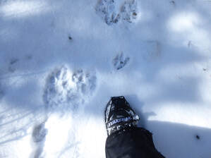
As we headed into the basin, Katie explained that the cabins were on forest service leased land. We saw Mary N's cabin along the way and saw where we normally park.  The snow wasn't even deep enough to cover the rocky section, so we had to watch our step. Luckily, it wasn't icy.  On this stretch, Katie noticed very large canine prints and many sheep tracks.  We surmised that two wolves were chasing the bighorns in this area, that very morning, since the snow was fresh.  

In the basin, we picked up another set of much smaller tracks alongside one of the larger ones. We figured these tracks were either a young wolf or a coyote following the wolves to eat some leftovers.  Luckily, we didn't happen upon a kill site; however, we did see where the sheep scattered in all directions and the wolves separating to surround the herd. Most headed to the river.

Then we arrived at our destination in the basin: the skull tree. This tree has various skulls hung on it, all painted on the forehead with birds. Mary N's niece is the painter. Inside her cabin are many of these artworks. We also saw a white-tailed deer run across the field.

Then we turned around and retraced our steps to the cars. We decided to eat lunch on the bridge before heading out to see the pictographs.

After a quick lunch, we walked the trail along the shore of the North Fork Sun to the pictographs, which lie at the head of Mortimer Gulch. Many have been faded by weather and some taken home as souvenirs, but many nice ones remain, especially hand prints.

After we hiked back to the cars, we finished by looking back at the cliff at the head of the basin. Katie explained what a nice hike it is in the spring.

Then we said our goodbyes in Augusta and headed home. We arrived back in Great Falls around 3:30 p.m.
Who went from GiG: Sara, Rose, Jaye,  Katie

Pix
1 Comment

Skidway, Feb. 17, 2020

2/18/2020

0 Comments


First Trip to New Area Provides Fun But with Harrowing Ride Home

Picture
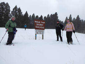
Thank goodness Amber was driving; some of us couldn't even watch the road, the whiteout was so bad we couldn't see the ditches or center of the road. Amber had to rely on the rumble strip and reflector poles. But first, the beginning:

Katie almost canceled the trip due to bad roads indicated on the road report over Kings Hill Pass, but she decided we should go anyway but drive via Helena and Townsend, only about 15 minutes longer to the trailhead at Skidway campground and home of the former Skidway Peak ski hill. 

It was a good choice as the roads were dry and clear until the last mile or so going into the former ski area. We had a stop in East Helena and arrived at the trailhead at 10 a.m. after leaving Great Falls at 7:30.

As we started on the trail, it appeared to be broken with both a snowshoe and ski track, so we had a fairly easy time for the first mile or so. Then the track became scarce and then disappeared altogether. We think people were doing a small loop through the campground area or up and back and not doing the entire loop. 

By the time we reached the ridge, we needed a break, but the wind had picked up and the snow had started. We grabbed a quick bite and continued on.  Katie had scouted ahead a bit, hoping to spot a blue diamond trail marker, but she climbed the Skidway hill instead and encouraged the others to do the same to claim a peak in the 2020 Peaks Challenge.

Then it was on to looking for the trail. Since there were no trees along the ridge, determining which direction the trail headed was near impossible as we didn't have our usual blue diamonds posted on trees to guide the way. We did see one trail, but it headed uphill. Katie didn't think that was the right direction, predicting it continued on to climb Grassy Mountain, so she took off on the downhill side and did spy a blue diamond--Whew! We were back on trail.

And the trail in this section in particular needed breaking. Amber followed by Roni did the brunt of the breaking, some of the snow knee deep.

The blue-diamond back-country markers were pretty easy to follow for the most part. In a few spots, we put up a piece of blue marking tape that Susan had brought along to help others in the future follow the correct way.

In the end, we were able to complete the entire loop of about five miles. By the time we reached the car, some of us were tired. Paula said it well, "I'm out of gas," which set up perfectly for a soak at White Sulphur Springs. By now, the snow was really coming down.

So Paula and Roni took in the warm waters (Roni had never been before), while Amber, Susan and Katie walked main street checking to see which restaurants were open on a Monday. They also stopped in to Red Ants Pants.

Then the group met back up and went to dinner. Roni had a bit of a reaction to the sulphur, so her skin was very red for a while.  We ate at Bar 47, and had a great waiter who catered to us quite a bit. From blue-cheese burgers to wedge salads, we enjoyed our food. Could be we were just hungry after our hard trailbreaking.

We finished before 5 p.m. so we still had quite a bit of daylight left. Katie talked to Amber--the roads looked snow-packed and icy most of the way home. However, going through Helena would take even longer since we were in White Sulphur now.

​Amber said she didn't mind driving in snow as long as it wasn't too icy. The road report indicated snow cover, but not black ice, so off we went--big mistake.  The roads immediately started to get snow covered; then it was snowing so hard it was hard to see the road; then the mesmerizing flakes started in; plus the temperature really dropped, so the inside windows iced up, making visibility even worse. The whole time we wondered where the plows were. We didn't find the answer until we reached Armington Junction: Two were are the gravel area.

The entire drive until Armington Junction was white-knuckle for Amber but she handled it well. We took a brief stop at Bob's Bar, but other than that, she drove for one hour and a half on very bad roads. At Bob's we wondered if we should just get rooms for the night, but decided to carry on. We came across several stopped vehicles, one in the ditch with its read still in our lane. Amber had to stop quickly to avoid hitting it. It was a near miss. At this point, Paula mentioned her cabin by Sluice Boxes. Again, we wondered if we should give up on driving for the night, but we kept going.  

Luckily, we made it back all in one piece and no going in the ditch.  I don't think the GiG has ever had this scary of a ride before. We were so grateful for a great snowshoeing day with the gals that ended safely.

Pix
0 Comments

Falls Creek, Feb. 15, 2020

2/15/2020

0 Comments


Icy Trail Necessitates Yaktrax, Careful Stepping on Way to Falls as GiG Explores Newly Opened Area

Picture
The gals decided to check out the new Falls Creek Trail, just recently purchased by the Rocky Mountain Elk foundation along with other entities. These groups were able to raise funds to secure an easement on this side to an area that has been landlocked for some time. Read more here.

Another new thing was a new face in our group: Paula P

We left Great Falls at 8 a.m. and got on trail by 10:15 after a quick stop in Augusta to pick up Viki. . Deciding that we only needed yaktrax and not snowshoes due to just a few inches of snow on the ground, we headed up the old road watching our step. The snow wasn't very deep; so between icy patches, we also had to keep an eye out for rocks and buried logs. We saw a few tracks: coyote and deer plus voles and birds.

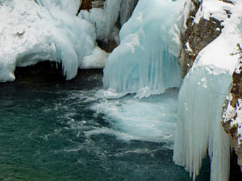
This hike is quite short, so it didn't take us long to arrive at the grand finale; after a few small water falls and ice flows that drew "oohs" and "ahs," we saw it: a massive falls cascading down the narrow valley of Falls Creek. Our vantage point was from above on a cliff; so again we had to watch our step as the kinnickkinnick was a bit slippery where it poked through the snow.

We continued on a bit farther until we had a nice view of the stream set against the mountains. By now, it was lightly snowing, so we really didn't get good views.  However, the weather was fairly warm and the wind calm, a surprise from the prediction of 35 mph gusts.

Then we retraced our steps to the cars, took off our yaktrax and headed to Augusta. On the way, we met a man walking at a fast pace. We stopped to see if he needed a ride somewhere, but he said he was just out for a walk, yet he seemed out in the middle of nowhere.  On the way back, we took a wrong turn and then went back the other way; the road was a bit rougher than the way we came in but not bad.

Then it was a late lunch at the Buckhorn Bar. Our waitress was friendly and laughed at our special orders and Brenda's wiping the pickle juice off her plate--after all, a pickle is green. The waitress said she would have done the same.

On the way home, Brenda told us funny tales from her school. Some of us learned about the term "furry," as a preferred gender type. 

We arrived back home at 3:15. Paula said she had a good time. We hope she joins us again.


Pix
0 Comments

Valley of Fire, Red Rock Canyon, Feb. 7-10

2/11/2020

0 Comments


We Should Have Brought our Climbing Gloves and Other Surprises

Picture
Bonnie did a heck of a job organizing a GiG trip to the Las Vegas area, but she forgot to tell us to bring climbing gloves--more on this later.

Our flight into Las Vegas was uneventful; we did see a few GF folks that some of us knew and visited with them.  After we landed, Bonnie was there to pick us up and take us to dinner at Brio, an Italian restaurant. We all liked our meals and then headed to Bonnie's house to get settled and discuss our first day of hiking, this one in the Valley of Fire.

Saturday dawned beautiful with blue skies and a breeze with a predicted high of 70 degrees. The next day, the winds were supposed to be 30 mph with a chance of rain and snow. This valley is very sandy, so we didn't want to get caught in a sand storm; nor did we want to get caught in a flash flood, another disaster awaiting those who dare the valley in rain with all  its washes.

Here, we took a series of short hikes, the longest being two miles; however, the scenery was so different from what we are used to that we kept stopping to take look around and take pictures. The vivid yellows, tans, whites against reds and oranges popped.We saw elephant rock, arch rock,  and a few others, all around a quarter-half mile each. 

We hiked up the stairs at Atlatl Rock to see the petroglyphs and decided to encircle it too for even more petroglyphs (half mile). Boy were some of us sorry we didn't have high top boots as our feet sank in the sand, filling our shoes.

The Fire Wave, perhaps the most impressive, was also the longest at 1.5 mile, but we also took a side trip of a half mile down a wash as well as climbing to the top of a knob for a picture opp--waving our hands, of course, in honor of the trail name. The white and red layers looked like painted stripes, forming pattern upon pattern in this area, including a wave pattern, hence the name. Beth noticed some rock that didn't look like it fit in the area. It was a conglomerate among the sandstone, which breaks apart into gravel.

We also hiked the White Domes trail (1.25miles), and along the drive, we took in the Seven Sisters, large sandstone monoliths some 20-30 feet high.

Finally, we toured the Visitor Center to learn even more about the area and its flora and fauna, from bighorn sheep to burros to desert tortoise to road runners to snakes (rattlers, gopher snakes, sidewinders) and lizards. We hoped to see tortoise and burros, but were disappointed. However, we did see a herd of bighorn sheep.

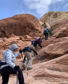
For Sunday, our second hiking day, we were off to Red Rock Canyon Conservation Area.We took two main hikes: Calico Hills, an up and down, up and back, hike among gorgeous red rock formations and Calico Tanks, a hike that leads to natural water storage areas and a view of Las Vegas. But we were in for a surprise on the Tanks hike: Bonnie didn't tell us to bring our hiking gloves on her packing list, but that is what was needed.

The beginning of the hike was pretty tame, flat on a wide path, which led to an Agave Burn area, where Native Peoples cooked, similar to dutch oven cooking. The cracked rocks and ash, many feet deep, are still visible.

Then about one third of the hike required rock scrambling, some sections with a bit of exposure.  When the cliffy areas got steep and the footholds narrow with drop offs, only three continued, due to the scare factor of getting back down. However, the views of the Vegas skyline and the unique rock features were amazing. The hike did require some nerve getting back down, which was tougher than climbing up, but we all made it without a scratch or a fall.

And did we mention the weather during the scrambling? It was very windy, gusts up to 30 mph, with some snowflakes. In fact, some views of the mountains looked hazy due to the snow squalls.  We all three froze and were grateful to get back into the car, nice and warm.

So with our last hike done for the day, Bonnie drove us around the circle to see a few more sights.  We did get out and hike one more half-mile section to Ash Springs on a brand new boardwalk.

On the way out, we went by the place said to most often have burros. We did't see any, but we did see hundreds of Joshua trees, a real treat. We also learned these 1,000-year-old trees aren't really trees, but rather a kind of yucca plant.

Then it was back to Bonnie's for a quick shower before eating out at a Mexican restaurant, Lindo Michoacan. Again, everyone liked her food.

The next morning, we helped Bonnie clean up a bit, stripped the beds, jumped on the air mattress and cleaned bathrooms and did some laundry before walking to breakfast at the restaurant located right in Bonnie's gated community. Then we tried to order a Lyft ride, since Katie had a 50 percent off coupon; however, no car confirmed the ride even after a half hour. So Katie cancelled and tried Uber. We got a ride right away.

We said goodbye to Bonnie who was headed to work for the afternoon. We had an interesting Filipino driver who used to be a caregiver for Roy of Sigfried and Roy of white tiger fame.  He said Roy was very demanding, talking about reading all night to him in dim light and wiping his butt with three people to help.Even with an occasional $400 tip, he said it wasn't worth it for what he had to do.  Interesting.

We got home with no other incidents.

Tidbits from our stay:
  • We told Bonnie she should earn extra money being a tour guide and call herself BJ Tours. Beth explained why she wouldn't want to be called BJ.
  • Maria learned about the Urban dictionary and will be looking up several items when she gets home
  • Susan had us walking in circles around Bonnie's house to get our steps in since we ended early due to the cold weather.
  • We walked around the neighborhood too to get in some steps.
  • We discovered that the Nelson or desert bighorn sheep are much smaller, but the females have larger and longer horns.
  • Some of our favorite things: fractures/fissures in the rocks, colored sandstone, conglomerate
  • Flora: manzanita, scrub/shrub oak, mesquite, mistletoe, choya, barrel cacti, ponderosa pine, pinyon pine, joshua tree.

Who went: Bonnie, Susan, Beth, Maria, Katie

Pix
0 Comments

747 Trail, Feb. 2, 2020

2/5/2020

0 Comments


 Race to Make the Superbowl Kickoff Speeds Gals on 747 Trail

Picture
We left Great Falls at 7:30 in hopes we would be back in time for the 4 p.m. Superbowl as some had parties to get to. The day was gray, promising some snow, but the roads were good despite overnight snowfall predictions.

So Mary N made good time, getting us on trail by 8:45 even though we stopped for a bathroom break at the Neihart Inconvenience store.

Wind was also promised along with the snow, but since we were mostly in the trees, we didn't feel it much. On the way up, Aaron Weissman stopped us in his ski patrol outfit, reminding us to stay single file along the edge and watch for skiers and boarders as we ascended the mountain.  Luckily, few were on the mountain today, probably due to the weather predictions of high winds coupled with the big football game.

We reached the top in one hour, forty minutes, possibly a record for us as it usually takes us a full two hours, and popped into the Top Rock Cafe for a snack and bathroom break. Nora kindly bought us all hot cocoa as we warmed up before tackling the long downhill on the backside of the mountain.

Then it was off we went to see if Katie's husband Tom had created some tracks for us. In the past, we have gotten lost on this trail as it isn't well marked. We have bypassed the turn and also gotten off track after the turn, so we planned to add more marking tape to the trees to better mark the trail.

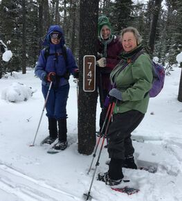
The trail starts on the O'Brien/Ranch Creek trail. O'Brien branches off and then we knew we needed to branch at the 747 trail marker.  As we went along, following ski tracks on Ranch Creek, we thought we had gone too far and bypassed the turn again, so Katie pulled out her Gaia gps to check. We were within a few steps. We did find the trail and headed down, coming upon Tom within a quarter mile.  He had gone the wrong way and retraced his steps so we wouldn't make the same mistake following his tracks. he had made arrows in the snow marking the correct way.
So we got that straightened out and put up more marking tape that Susan had brought with her. But soon we rand out, so tthe last half of the downhill still doesn't have good markers.

We made it to the bottom of the mountain and then had to encircle it on the snowmobile trails. Luckily, no snowmobiles came by today, although we did hear engines in the distance. We figured the superbowl was keeping everyone partying before the game.

As we traversed the snowmobile trail, Mary kept wondering if we went too far as it is a good distance before we pick up the O'Brien Creek trail again, but we didn't miss any turns this time, spotting the yellow cross country skier sign that warn snowmobilers of skiers crossing their path. 

About this time it really started to snow, covering our tracks as we went. Then the wind started picking up too; we were so glad to be ending and not starting. Mary shook the snow off her car, and we tried to keep it from blowing in as we put our gear back in.

We arrived at the car by 1:30 pm and arrived home before 3, well ahead of the kick-off time of 4:25.

Katie's Easy Pear Parmesan Appetizer Recipe

3-4 paremesan rounds
Sliced pears
Cherry jam
Softened cream cheese.

​Cook premade or make your own parmesan cheese rounds by putting in microwave for 1 minute or one minute 30 seconds until crisp. Use shears to cut into wedges while still warm.

Spread some cream cheese on the wedges.
Add a dollop of cherry jam (cherry jalepeno is really good too)
Add a pear slide to the top.

0 Comments
    How to Download Pix
    ​How to download with iphone, it's easier with OneDrive app
    ​Hikes by Year
    ​Pictures

    Archives

    October 2021
    September 2021
    August 2021
    July 2021
    June 2021
    May 2021
    April 2021
    March 2021
    February 2021
    January 2021
    December 2020
    November 2020
    October 2020
    September 2020
    August 2020
    July 2020
    June 2020
    May 2020
    March 2020
    February 2020
    January 2020
    December 2019
    November 2019
    October 2019
    September 2019
    August 2019
    July 2019
    June 2019
    May 2019
    April 2019
    March 2019
    February 2019
    January 2019
    December 2018
    November 2018
    October 2018
    September 2018
    August 2018
    July 2018
    June 2018
    May 2018
    April 2018
    March 2018
    January 2018
    December 2017
    November 2017
    October 2017
    August 2017
    July 2017
    June 2017
    May 2017
    April 2017
    March 2017
    February 2017
    January 2017
    December 2016
    November 2016
    October 2016
    August 2016
    July 2016
    June 2016
    May 2016
    April 2016
    March 2016
    February 2016
    January 2016
    December 2015
    November 2015
    October 2015
    September 2015
    August 2015
    July 2015
    June 2015
    May 2015
    April 2015
    March 2015
    February 2015
    January 2015
    December 2014
    November 2014
    October 2014
    September 2014
    August 2014
    July 2014
    June 2014
    May 2014
    April 2014
    March 2014
    February 2014
    January 2014

    RSS Feed

    Girls in Glacier and Katie Kotynski

Contact Us
Copyright 2014-2022 Girls in Glacier
All pictures copyright of individual photographers; no use granted without permission