Girls in Glacier | WELCOME
Like us on Facebook
  • Home
  • About Us
  • Blog
  • Hikes
    • Hikes 2021
    • Hikes 2020
    • Hikes 2019
    • Hikes 2018
    • Hikes 2017
    • Hikes 2016
    • Hikes 2015
    • Hikes 2014
    • Hikes 2013
    • Hikes 2012
  • Flowers/Trees
  • Helpers
  • Goodbye
  • Contact

Cracker Lake, June 28, 2018

6/29/2018

0 Comments


Cracker Lake Shows Glacial Till on Cloudy Day; Not Usual Milky Aqua

Picture
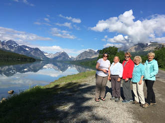
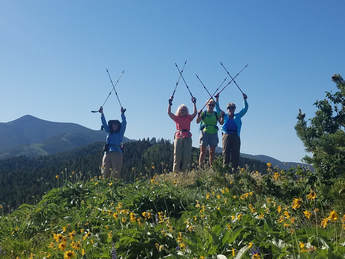
The cow parsnip jungle enveloped us in mist up as we embarked on our hike to Cracker Lake on Saturday, July 28. Our intrepid hikers - Josy, Cathy, Anita, Sara, Susan, and Amy - left Great Falls at 5 a.m. and successfully managed to find parking spaces at the Many Glacier Hotel by 8 a.m., an impressive feat this time of the season, before jumping on the trail staying ahead of the first horse ride of the day.  

Not accustomed to the high humidity, the dampness was noticeable on our way through the cool morning walk with perfect reflections of the mountains in Lake Sherburne. Even though it was cool we heated up on the trail, and Anita might have very well discovered her trail name, Steamy, as her glasses continually fogged despite her best efforts to keep them clear.  

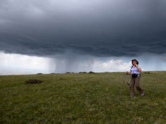
The least desirable section of the Cracker Lake trail is the potential to walk behind the horses since they tend to muck up the path in certain sections. Our early departure meant we were well ahead of them, so we enjoyed a decent trail only dodging puddles here and there from a recent, and much needed, rainstorm. On the switchbacks climbing the bulk of the 1400 Ft. in elevation gain, we played leap frog taking turns in the lead allowing people to rest, if needed, as well as to give everyone a chance to talk. Crossing the rock slide a couple of miles into the hike, Anita spotted a Boreal toad with its distinct white stripe down its back, which was quite a find since they are a species of concern in Montana. That was our most impressive wildlife sighting of the day.  

One feature we noticed as we walked along the creek was the cloudiness of the water. We weren’t sure if it was silt from the recent rainstorm, but Cathy noted it had not been that color in previous visits. Crossing the bridge at Canyon Creek was a challenge only because the trail leading to the bridge was sketchy. One path went up and around an enormous boulder, and the better way (at least on the walk in) appeared to be picking our way on rocks through the creek. After successfully maneuvering this obstacle, we gained more elevation through thick vegetation where many of us called out to let bears know we were passing.  

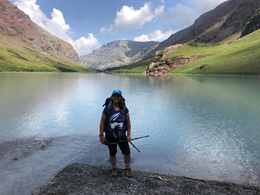
Soon the subalpine vistas opened and we enjoyed the beautiful views of Cracker and Siyeh Mountains making up the wall behind, as well as the spectacular scenery of the valley behind us.  The initial view into Cracker was gorgeous with perfect reflections of the mountains and snow in the water. The color wasn’t what we expected since the milky hue of the stream obviously originated at the lake, which was also more of a cloudy color and not the vibrant blue/green of Cracker Lake’s reputation. We suspect the difference was due to the melting of nearby snow fields because when Josy and I (Amy) hiked to the other side of the lake to explore the mining ruins, the inlet was the same milky color as the stream. Normally, the rock flour reflects the sunlight giving the water the surreal appearance, but there was obviously hit the saturation point with the recent run off to allow the blue-green light waves to be reflected from it.  

When we reached the lake, our goal (after a stop at the somewhat catty-wonker outhouse) was to lunch upon the rocky outcropping.  After a bite, Josy and I hiked to check out the remains of the brief mining escapade of the late 1897 where copper was supposedly discovered on the south end of the lake. This creating a flurry of activity as prospectors carved a “road” along Canyon Creek hauling in the enormous steam boiler and tens of tons of gear required to set up the operation with a saw mill and equipment to process the ore. Josy noted the extreme heaviness of just the small door on the boiler, so it’s mind-boggling to consider the effort required to bring back everything. The poor horses and mules! There’s also a 1300 ft. deep mine dug into the hillside, although we couldn’t find it. Talking to others who’ve been back there, it sounds like it was beneath the snowfield a couple of hundred yards behind the iron ruins.  

One question that arose during the hike is how Cracker Lake got its name. According to the legend, supposedly the prospectors who found the copper deposit left a tin of crackers in some rocks at lunch, but could not find them upon their return. This led to calling it, “The Lake where they left the crackers,” and subsequently Cracker Lake. 

It’s difficult to envision a mining operation at the end of this pristine lake, but we have to remember the early visions for the potential of this area weren’t focused on recreation. Before the park was established, optimum use of the natural resources was the primary goal, whether through mining, logging, hunting, or agricultural. And during this period of 1898 to 1902 when the mine at Cracker Lake was a reality, the small town of Atlyn, replete with a post office as well as several saloons, was thriving during its brief existence. Named for David Greenwood Atlyn, one of the backers of the mine and namesake to Atlyn Peak, the remaining buildings are now under the waters of Lake Sherburne when the valley filled in 1921 after the construction of the dam.  

Once we regathered at the big rock, we left at 1:15 at a brisk walk in an attempt to stay ahead of the 2 horses at the lake. We had a few slips at Canyon Creek on other side of the bridge, and 3 of us squeezed up and over the large rock on the bank. We went back and forth following or passing the horses for a short time, until near the end when we let them go by for the remainder of the walk. The trail was undoubtedly in rougher from the horse traffic on the way back, but it was good to see mud at the end of July.  

We arrived back at the parking lot a quarter before 5 p.m. and made a beeline to the hotel for a potty break and bite to eat -- as well as some delicious huckleberry margaritas for a couple of the ladies -- before heading back to Great Falls. We made it home by 9 after a wonderful day on the trail! 

Who went: Josy, Susan, Kuntz,Sara, Anita,  Amy


0 Comments

Bullhead Lake, June 2018

6/25/2018

1 Comment


Oh My,  Bears, Moose, Foxes Highlight Day in Many Glacier

Picture
Even though the day started out rainy, it didn't end that way. Our drive from Great Falls (6 a.m.) had us in showers for about one hour, but by the time we hit the trail at 9:30, the sun had come out.On our drive in, we spied a bear just off the road. He was quite small and probably a black bear but it was hard to see through the tall bushes to get a good look. 

Our hike to Bullhead Lake was a day to die for: gorgeous views on the way in and all along, cool weather and threatening clouds but no rain and not too much wind.  We also didn't see that many hikers on the trail. Those we did see told us to watch for two small bears as well as moose. We did see their tracks but we never did see any as we were hiking. We visited Fishercap Lake, Red Rocks Lake, Red Rock Falls (Katie, Mary and Karen scrambled up the rocks to look down on the cascades), Bullhead lake and finally Wilbur Falls.

We ended our hike around 2:30 pm and headed to the Many Glacier Hotel/Lodge to look around and have a late lunch/early dinner. On the way, we saw another bear, this time a grizzly rototilling a side hill above the turn to the lodge. He was huge, with a large hump and golden face and back.

At the lodge, we wanted to see the new double helix staircase that was rebuilt after having been taken out to accommodate a gift store upstairs (gifts and a coffee/snack shop are now downstairs, taking up part of the old auditorium space).It is gorgeous and almost identical to the original, the only thing is the railings are closer together to meet code (no kids can slip through or get their heads caught). We did a bit of shopping and then headed out to the deck to enjoy the view, at which time we spotted a moose across Swiftcurrent Lake. After watching her eat some willows, we went into the Iinterlaken Lounge to eat.  Interestingly, a wedding party was there as well, bride in her gown and all.

As we walked around the lodge, we noticed that the side-by-side of glaciers comparing what they looked like in the early to mid 20th Century to the 1990s that adorned the hallway leading from the lobby to the dining room were missing.No one at the desk knew what happened to them, so Katie filled out a form requesting information, leaving her email. Before the end of the day, she received a message that said the pictures were a fire hazard as people stopped in the hallway, that they were being stored and would be brought back next year but would be placed in the lobby area.

After a delightful lunch, we headed home (seeing two foxes along the way, one trotting right next to the road), but not before stopping in Valier for ice cream and a stretch break in Browning.  We arrived home by 8 p.m.

One calamity on trail: Denise fell on ball-bearing type rocks, but she wasn't injured too badly; just a bit of a bruise on her elbow.
Who went: Gail, Mary S, Denise, Linda, Karen, Katie

Katie's Pix
1 Comment

Porphyry Peak, July 24, 2018

6/25/2018

0 Comments


After-Work Hike to Porphyry Peak Leads to After Dark

After getting a later-than-expected start (around 5 p.m.) due to waiting for a no-show, seven of the GiG headed to the Little Belts for an evening adventure. When we arrived at the top of Kings Hill Pass, parked and started walking, we had to reroute from the trail to the dirt road due to construction in the campground.

Without snow, the road is easy to see and follow. Apparently, the forest service was taking down dead trees and had closed the campground.  Instead of continuing up the road, we decided to go up the gut of the ski hill. Going this way, gave Mary S the workout she wanted. She had a full backpack with about 30 pounds to get in shape going uphill as she was getting ready for a backpack trip.

The climb was a good one, but everyone made it easily.  At the top, we stopped at the picnic tables to have dinner and enjoy the views of the mountains. A few of us climbed up the lookout tower to get even better views.  Unfortunately, the lookout wasn't in the tower at the time.

Then we went down the road that curves around the side of the peak.
​
After, we jumped int o the cars and were going to stop at Bob's Bar, but it was closing at 9 p.m and it was almost 9 when we got there.  Then we continued on to Monarch and stopped at Cougar Canyon but it too was closed. So we arrived home at just after 10 p.m.

​Who went: Kuntzie ,Gail, Sue Julie, Josy, Mary S, Susan W,
0 Comments

Hiawatha and Blackfoot Float, June 17-19, 2018

6/20/2018

1 Comment


Rain, Overboard, Crash, Laughs on Hiawatha Bike, Blackfoot Float

Picture
Where do I begin on this one? Two women overboard? Biking in the dark on an almost two-mile long tunnel? A bike crash? Rain? Hot springs?

It was a wet weekend, a very wet weekend or to be more precise, a Sunday and two weekdays, which started after having breakfast with our hubbies for Father’s Day (leave time 10:30 a.m.) before heading out for a rainy drive to Missoula to pick up Susan, who was on her way from two days in Hamilton with her husband. We were glad we decided to forgo hiking Rogers pass for the milder and less wet Kim Williams trail in Missoula.

Missoula was just a bit overcast, so the three-mile hike along the Clark Fork River was pleasant. We all remarked at how fresh and wonderful the breeze felt as we enjoyed the river walk.  We didn’t have time to hike up Mount Sentinel, so we had to save that for another day.

Now that we had Susan, we had 11 of our ladies with one more (June) after we got to Quinn’s Hot springs in Paradise, Montana, where we would sty the night. We arrived at just after 4 p.m., giving us time to check in, get settled, and then head to dinner at the Harwood House. As the person with the reservation, Katie had to sign that we wouldn’t lose any towels (had to check them out and back in with the desk), lose any keys or “play chicken” in the highway, realizing that the speed limit was 70 mph. Fees were $40 for a “lost” or “stolen” towel and $10 for keys.

Katie and June both remembered the look of the old hot springs, bar and Harwood House restaurant, having lived in Western Montana (June in Plains and Katie in Alberton and Superior) in the late 70s and early 80s. It was pretty shabby back then, but everything is quite nice now with new cabins, even across the highway along the river (these cabins are pricier with the river view but also right next to the RR tracks).

Our meal at the Harwood House was quite good, just as Mary N told us it would be. The soups everyone particularly commented on. Then those who wanted to soak, headed for the pools, while others relaxed on the edge and enjoyed a pleasant evening that only produced a few sprinkles before an early bedtime before our big ride. We knew that the next day would probably bring showers, however, with a 70 percent chance predicted.

The next day, some of us had an 8 a.m. breakfast at the Harwood House (the earliest they open with no place else for miles to have a bite) while others ate in their rooms before we hit the road at 9 a.m. for Lookout Pass and our Hiawatha Bike Trail ride. We gained an hour going into Idaho, which is on Pacific time, so we arrived at 9:30 a.m. to pick up our lunches (our lunches came in a nice Hiawatha Trail souvenir day pack), passes, shuttle tickets, bikes and helmets. I must say it was a bit disorganized: they didn’t have the right number of lunches ready, they left off lettuce on a veggie sandwich instead of a turkey one (had to be remade due to Bonnie’s lettuce allergy), gave us 11 instead of 12 bikes (luckily, we counted before we left) and then didn’t put a headlamp on the last bike (which we didn’t discover until we got to the trailhead). Again, luckily, one of the trail marshals had an extra light as those tunnels are dark.

A funny side note: many of us hadn’t ridden bikes in a while, so we were asking how to change gears, etc. on the bikes. Susan asked so many questions, that the trail marshal finally said, “I think you are a good candidate for walking your bike. At least through the tunnels.” Ha ha! P. S. Susan had no issues with her bike.

It was 10:15 a.m. before we really started as we all rode around a bit getting used to the bikes. (Another side note: they only have a one-stall toilet for both sexes, so it takes a while for a group). Then we faced the first obstacle right off the bat: the looooong tunnel. June led us into the tunnel walking our bikes so that our eyes could get adjusted before we headed out. This was a very good idea as we had heard from Anita about her crashing and two of the Canadians also said they crashed in the tunnel. We made sure to take our sunglasses off and turn on both our headlamps and the bike headlights.

Our first hour and a half was glorious, cloudy but a nice 60-degree temperature. We leisurely pedaled and stopped at each interpretive sign to read about the history. Unfortunately, the trail crew had places large rocks to slow riders before each of the interpretive signs, and Catherine hit one as she attempted to go between two rather narrowly spaced boulders. Luckily, she wasn't hurt. But we told her she would have a souvenir bruise of her trip.

Along the way, we enjoyed the views into the snowy mountains, the tunnels and each trestle to its fullest, marveling at how high each was, how beautiful the firs trees’ new growth was as we gazed down on trees over 100 feet tall from trestles that were over 200 feet high. Amazing. And we had fun with all the tunnels as well.  The trail has 10 tunnels (one—the long one—we went through twice) and seven trestles. At our third trestle, we sat along the edge of raised railroad ties and ate our lunch, which was 11:45 (12:45 our time).
​
Then the rain came at the half-way mark just a half mile from lunch. Luckily, it was right at the bathroom, so we took a break and those who didn’t have rain gear on, quickly put it on. Then our pace quickened a bit as the spitting turned to a steady drizzle. In fact, the last two miles, Kuntzie, who was in the lead, started hoofing it. Some struggled to keep up, but the trail was turning muddy, putting a “Hiawatha Stripe” down our back from the mud kicked up by the rear tire. And due to the rush, we made the 1:15 bus; otherwise, we would have had another hour and a half wait in the rain for the next shuttle.

We hardly saw another soul on the trail; probably no one wanted to bike on a rainy Monday (70% chance of rain). At the end, we saw a few more headed up and a few groups passed us trying to make the early shuttle too.

The shuttle left us off before the long tunnel again, so we had to go through it second time. This time it was a bit eerie with a weird atmosphere that gave Linda a sudden headache and made others struggle to see. The rain had made the inside air extremely muggy and foggy, but we all made it out without crashing. Kuntzie, the speed demon, slowed way down too at this point, facing a bit of uphill as well as the mugginess.

It was 3:30 p.m. before we loaded all the bikes up and got back to Lookout Pass to turn the equipment back in, and head to Wallace, Idaho, for some shopping and dinner. We had to skip hiking the Polaski trail due to the weather and the lateness of the hour—there is always next time! We were going to eat at one restaurant that Katie remembered as being good, but the locals said “Not anymore” when asked if it was good, so we took their recommendation of the City Limits Pub and Brewery. Boy, did it have an interesting menu. Two gals had the homemade raviolis (fresh that morning), one with sage brown butter sauce and one with marinara and both said they were amazing. They served a lot of food, for sure.
Then back to plains on a rainy evening to soak or just relax.

The next day, it was breakfast and check out by 9:30 for our raft trip, but not before saying goodbye to Susan and June, who passed on going down the river.  Katie called to double check that the float down the Alberton Gorge was still on due to rain (might have raised the river too high to navigate safely) and due to predicted afternoon thunderstorms. Tiffany said we were still on. However, she didn’t’ tell us the whole story.

We arrived in Missoula at 10:45 and stopped at a coffee shop/sandwich shop to pick up lunch and then walked the one block to the raft company. We all paid and then started to gear up. It wasn’t until we had our gear and had paid that we found out we were not going down the Alberton Gorge after all but instead going down the Blackfoot. Some of us were very disappointed, more in the fact that the raft company had not told us. We should have been able to decide whether we still wanted to go or not since the Gorge wasn’t an option.

However,  we accepted it as the guides had already-- at this point-- hitched up the rafts and were expecting a trip. The drive to the put in was a full 45 minutes and it drizzled a bit at times on the drive, but the day actually looked pretty good, better than predicted. It had taken us almost an hour to put on wetsuits and get ready.

We were in two rafts: Katie, Kathy, Kuntzie, Mary and Susan with two guides and Bonnie, Linda, Jeanne, Gail and Catherine in another with one guide. Bonnie was unable to paddle due to a shoulder injury.  In hindsight, we should have had Bonnie in the raft with two guides to balance the paddling.

Everything went pretty well to get started; we all put on our own gear without much instruction other than to put on our lifejackets tightly.  So we got into the rafts and took off, the first boat waiting for the second to get on the water.

We didn’t get any instruction as to how to hold the paddles, how to work together, what the commands were, etc., which those of us who had gone on guided trips thought a bit odd. However, Katie thought that the Blackfoot was such an easy river that maybe it wasn’t needed. Indeed, the guides briefly covered safety, explaining how to put your feet in front of you if you fall overboard and how to keep yourself upright and push up and over if you happen upon a “strainer,” a jam of logs and debris that can suck a swimmer under and catch her feet. But the guides said, “This won’t happen today.”  Famous last words, that appeased Kuntzie since she doesn’t swim, and she was nervous, very unusual for Kuntzie.

So a mile or two into the ride as we were admiring the herons, the mergansers (including the ducklings), the osprey and the high cliffs and wildflowers, the gals in the lead boat looked back after a small rapid (all were mostly Class I with some low Class IIs), and were shocked to see that it appeared Bonnie had fallen in. Then we saw Bonnie in the boat but another person floating toward us, with feet first, just as instructed. We at first thought it was Linda as we strained to see who was on the boat and then realized it was Gail.  But we saw that Bonnie was soaked. We were confused but surmised that maybe she had gotten wet trying to rescue Gail.

Cathy said, “Gail is a goner,” as we felt a sinking feeling in our gut watching her float along. Katie said, "Shouldn’t we paddle backward to try to get her?" and the guides finally said yes, but the other raft paddled forward and caught up to Gail first. However, the gals struggled to pull her into the raft. In fact, her life jacket pulled almost all of the way off, covering her face. It had not been tight enough.  Now Kuntz said, “There is a headless life jacket,” as we couldn’t see Gail’s head anymore.  Finally, the guide on the second raft was able to pull her in (He told the gals to "move aside" and grabbed her with ease), but we saw her just lying in the bottom of the raft, leading us to believe the cold water had brought on a heart incident since Gail has heart problems.  Later we learned this was not the case. It was just that  the life jacket had wedged itself around her chest and neck and the others had a hard time getting it off to put it back on right.

After what seemed an eternity, the guides and the gals in the second raft signaled that all was okay. It was now that the main guide on the first raft admitted that the guide in the second raft was brand new and that this was his first time leading a boat down this river and that he was supposed to be following the first craft’s line. In fact, our guide was only in his second season and the other guide on our boat was a newbie too.

The rest of the trip was uneventful other than Kuntzie not paddling anymore as she was holding onto the cooler’s tether rope and said she wasn't going to let go.  She also said, “Why wasn’t Gail screaming? I would be!” Many of us said we would be too, but Gail is a pro and a calm head. She was cold but not injured at all and followed instructions to a tee.Her technique was textbook.

Toward the end, Susan “made” the newbie on our boat take the steering oars and be our guide. She was telling him to show us points of interest and tell us river stories, but he didn’t have any being a newbie. So she said he now had a story due to some of our gals going overboard.

When we got to the takeout, we heard the whole story: Raft 2 had gone over a “pourover,” a large rock with just a bit of water rushing over the top but enough to create a steep drop with backwater. It tossed both Bonnie and Gail over; however, the other gals were able to grab Bonnie right away, who was holding onto a tether on the side of the raft.The raft didn't have a rope on it so there was nothing for Gail to grad onto.  Ironically, on bus trip to the put in spot, Jeanne had asked if the guides had ever gotten hung up on a large rock that was partially submerged. They said  they hadn’t.

On the way back in the bus, we were all laughing and joking around and making a bit of fun of the guides, Zach, John and Skyler, who really deserved a bit of teasing. In fact, I think they learned a lot from our group, and we did too. Both Bonnie and Gail were cold, especially Bonnie as she was shaking. Those two had been wet for most of the 17 miles; and at the end, we all started getting a bit chilly due to the wind coming up. And on the bus, it started to pour. We had made a day of it without rain from the sky, just the rain from the rapids.

After changing at the raft company office, we headed back out to Great Falls around 5 p.m. We decided we would eat fast-food in Helena instead of stopping in Missoula before we left. And yes, we had to go through Helena instead of Lincoln as Highway 200 was closed over Rogers pass due to rivers flooding in the area. In fact, all of Augusta was flooded with other areas threatened due to the Sun River, Teton River, Missouri and many creeks overflowing. So it was Arby’s in Helena and then home.

What a wet and wild weekend we had with lots of laughs to boot and everyone safe at the end. Thank goodness.

Who went: Kathy M, Bonnie J, Linda, Gail, Kuntzie, Susan, Sue, Catherine, Jeanne, Mary S, June, Katie

Kathy's pix
Katie's Pix
1 Comment

Rogers Pass and Sculpture Garden, June 14, 2018

6/15/2018

0 Comments


Chocolate Lilies and Canadians Welcome New Hiker

Picture
We had our first hike with Michele on a fun quick trip up Rogers Pass followed by a visit to the HI-Country Beef Jerky factory and gift store and then to the Blackfoot Pathways Sculpture Garden.

The hike to Rogers pass didn't disappoint on wildflowers on the way up, with dark blue larkspur, glacier lilies, paintbrush, bistort, arnica, phacelia and the rare chocolate lily dotting the hillsides, just to name a few. However, the alpine forget-me-nots, douglasia and pasque flowers were well past their prime. And the top of the pass was very windy, forcing us to take a quick look at the view before we headed back into the trees to have a bite of lunch.

On the way down, one of our in-house scientists, Josy, showed us some moss/bryophyte  that turned almost instantly green when she spat some water onto i, bringing it out of dormancy.  Josy also told us that the leaves, flowers and roots of a plant often have different effects on people. For example, the Valerian root can be used as a sedative, but she explained eating the flower or leaves might not have the same effect.

Once we got down, we headed to the Hi-Country Beef Jerky Country Store and factory. We enjoyed looking around at the various Montana gifts: huckleberry everything, 406 t-shirts and sampling pemican and other dried beef products.

Then we toured the sculpture garden after taking a quick trip off the road a quarter mile by Leepers to see Kuntzie's cabin. She is going to sell it as both she and her sister aren't interested in maintaining it. It is right on the creek and has huge ponderosa pines surrounding it, making it very peaceful and beautiful.

Then we said goodbye to our Canadian friends as they were headed over Flesher pass and on to Helena for the night before they eventual destination in Idaho for the Spinderella bikeride. But we had another adventure or two involving animals. First, a cow elk sauntered into the road right in front of us, making Katie brake rather quickly.  Then instead of running away, she stood, looking at us and sniffed the air before wandering back to the same side of the road from which she came. It brought back bad memories for poor Maria who had totaled her new car hitting a deer on another GiG trip. She said an elk would have really totaled the Katie's car.

Then five minutes down the road, Susan spied a young spike bull moose in the marshy area, right off the road. Katie turned around so we could all get a good look. He was magnificent.

Finally, we headed home but not before we stopped at the Mennonite/Amish store/cafe in Vaughn to get a few goodies.

​Who went: Kuntzie, Maria, Anita, Michele, Susan, Josy, Katie

PIx
0 Comments

North Fork Highwoods, June 9, 2018

6/9/2018

1 Comment


Flowers Dot Ridge Overlooking Mountain Range

Picture
Although the arrowleaf balsamroot were fading, we still happened upon a stand or two in full yellow bloom. And we saw many other flowers: arnica, lupine, chickweed, larkspur, bistort, threadleaf phacelia, pink and white sticky geranium. The lupine were especially showing off in their purple-gorgeousness.

We hiked to the ridge and then went off trail to the top of a little knob where we could see the mountains in both directions before descending back down to the trail, going about three-miles.Along the way, we heard of Bonnie's exciting new adventures: her move to Las Vegas and new job at a charter school and her required class to be certified in Nevada.

We left GF at 6:45 a.m. and were home around 11:15 a.m.. Nice flower walk that still left us with time to hit the Farmers Market and enjoy the afternoon.
​
Who went: Roni, Mary, Deb, Bonnie and Katie 

1 Comment

West Butte, June 7, 2018

6/8/2018

1 Comment


Thunderstorm Speeds Hikers on Ascent/Descent of West Butte

Picture
Lightning strikes, the power of thunder and gorgeous clouds reminded us of the fragility of life as we hiked to the top of West Butte in the Sweet Grass Hills.

The day started out 7 a.m. with a quick stop in Shelby and then continuing to Sunburst to pick up our sister gals hiking group of Canadians, the WoW (Women of Wonder). All told, we had seven from the U. S. and 7 from Canada, plus one guy. Then it was on to the parking spot along a gravel road.

Our hike started at 9:30, with the pressure of beating a 3 p.m.-predicted thunderstorm to hustle us along. Katie’s husband Tom was our official leader, the one who had the GPS to keep us off private land and also help get us back down through the tree section, which can be a bit tricky. He was also the one who reminded us to gear up quickly and move up the mountain as quickly as we could, which most of us found easier said than done as the way is up, up, up. And this adventure was off-trial, always an experience of route finding.

On the way up, we occasionally turned around to cool ourselves in the breeze and check to see how far off the clouds were. We also enjoyed the flowers: lupine, golden peas, larkspur, wild onion, crazy weed, silky phacelia, death camas, and miles of thread-leaved phacelia, more than we had ever seen before.

Some of us struggled, all of us felt the steepness and one had to turn around about a third of the way up. The terrain was as follows: Meadow, grassy-tufted hillside, pine forest, talus, forest, talus and athen meadow on top.
Then we had an unexpected storm, one that came in around noon, just as we were cresting the top.  Luckily, we had Beth Thomas who had an app on her phone that tracks storms. She could tell us exactly where the storms were and if they were electrical and how strong.

We quickly got off the top and took shelter among the trees as the lightning storm swirled around us, hugging the butte. It didn’t produce much rain and kept to the side of us, but we did get some pea-sized hail as we ate our lunch, huddled with our colorful ponchos on. When the storm subsided, we went back on top to enjoy the views a bit more before we headed down. We also took a group shot by the cairn and signed the register.

Then we had to scoot as another storm cloud was forming off to the west. We started our steep descent through the talus, then through the trees and then the promised 3 p.m. storm started looming with booms out in the distance, heading our way.

The leaders beat foot to the coulee to get off the mountainside, while the rest of us encouraged everyone to get down as quickly as possible. And the rain was really coming down now.  If caught amid the lightning, we reminded everyone to flatten against the ground and for sure not to hold poles up. Even though the storm was a bit frightening, it was also awe-inspiring: The clouds amazing; the lightning and thunder powerful.

Thankfully, we all made it down safely, one with legs jiggling and one with knees locked up but with everyone smiling. For some, the Sweet Grass Hills were on their bucket lists. For others, they now have two out of three buttes completed, with East Butte, the largest and longest hike yet to do, hopefully, next year.

We said quick goodbyes as it was still raining and headed down the now-gumbo road that gave us a squirrelly ride, the Canadians back home and the U.S. gals to Shelby for dinner at Ringside Ribs, a misnomer as they serve everything from pasta to steaks to pizza to fish and chips. The gals who got the barley soup particularly liked it. And the waitress really impressed us as she memorized our order (for all 8 of us).
​
We arrived home around 8.

Who went: U.S. Katie, June, Camille, Kuntz, Brenda, Beth, Sara; Canada: Pat, Linda, Deena, Sharon, LaVerne

Pix
1 Comment

Pioneer Ridge, June 2, 2018

6/2/2018

0 Comments


Orchid Walk Awesome with Calypso Fairy Slipper and Many More

Picture
An early morning (6:30 a.m.) trip to Pioneer Ridge to see the orchids turned out perfectly: We saw the calypso fairy slipper orchids and then some: chickweed, larkspur, arrowleaf balsamroot, blue-eyed Mary, yellow violet, bluebells, woodland star, Oregon or holly grape, false Solomon seal, nine-leaved biscuitroot, sticky currant, fern-leafed desert parsley, shooting stars, groundsel, arnica,and lots of virgin's bower clematis.
​
 The views into the Little Belts were amazing with the green almost hurting our eyes it was so bright. We arrived back home at 11:30; a.m. after our short three-mile walk.

Who went: Christi, June and friend, Carolyn, Kuntzie, Karen, Susan, Denise, Sara, Catherine, Brenda, Katie

Pix
0 Comments
    How to Download Pix
    ​How to download with iphone

    Archives

    February 2021
    January 2021
    December 2020
    November 2020
    October 2020
    September 2020
    August 2020
    July 2020
    June 2020
    May 2020
    March 2020
    February 2020
    January 2020
    December 2019
    November 2019
    October 2019
    September 2019
    August 2019
    July 2019
    June 2019
    May 2019
    April 2019
    March 2019
    February 2019
    January 2019
    December 2018
    November 2018
    October 2018
    September 2018
    August 2018
    July 2018
    June 2018
    May 2018
    April 2018
    March 2018
    January 2018
    December 2017
    November 2017
    October 2017
    August 2017
    July 2017
    June 2017
    May 2017
    April 2017
    March 2017
    February 2017
    January 2017
    December 2016
    November 2016
    October 2016
    August 2016
    July 2016
    June 2016
    May 2016
    April 2016
    March 2016
    February 2016
    January 2016
    December 2015
    November 2015
    October 2015
    September 2015
    August 2015
    July 2015
    June 2015
    May 2015
    April 2015
    March 2015
    February 2015
    January 2015
    December 2014
    November 2014
    October 2014
    September 2014
    August 2014
    July 2014
    June 2014
    May 2014
    April 2014
    March 2014
    February 2014
    January 2014

    RSS Feed

    Girls in Glacier and Katie Kotynski

Contact Us
Copyright 2014 Girls in Glacier
All pictures copyright of individual photographers; no use granted without permission