Girls in Glacier | WELCOME
Like us on Facebook
  • Home
  • About
  • Calendar
  • Blog
  • Flowers/Trees
  • Helpers
  • Goodbye

Flattop and Elkcalf, Aug. 25, 2020

8/27/2020

1 Comment


Climbing Two Peaks in One Day Involves Berries, Bushwhacking

Picture
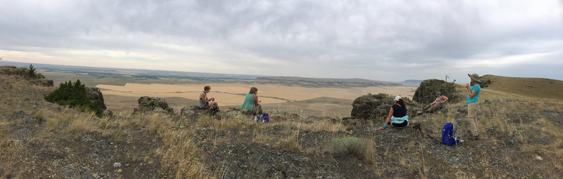
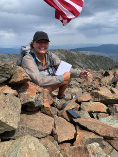
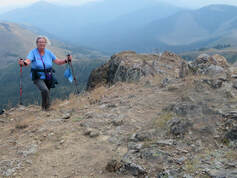
Three GiG members from the east side plus two husbands met one GiG member from the west side at Marias Pass for a climb of two peaks: Flattop and Elkcalf in the Badger-Two Medicine area, across Highway 2 from Glacier Park.

We left town at 6 a.m. in a haze of smoke, which cleared as we traveled north, making our sunrise pretty. With no traffic (usually this time of year we pick up farm traffic early in the morning on the Valier cutoff), we made good time and arrived at the pass in  two hours 15 minutes, even with a bathroom break in Conrad.

The skies were fairly clear when we started out on our hike, but by the end of the day, the smoke was thick as the west wind picked up and blew it in.

We got on trail well before 9 am and easily climbed Flattop, about a mile and 600 feet from the parking area.  It took us a bit longer than normal as the huckleberries and whortleberries were ripe and plentiful. We also saw elderberries, currants, mountain ash berries and raspberries over the course of our hike. On top, we had good views; the smoke hindered a bit, but it hadn't really moved in yet. However, when we looked west, we saw a wall of haze.

From there, the going got a bit trickier. From Flattop to Elkcalf, there is no real trail.  We had to step over much deadfall from the Skyland fire in 2007. Read more here and here. Luckily, the deadfall wasn't too hard to step over.  It didn't bring back memories of Colorado mountain, which three of us had been on, or anything that bad. In this area, we found the wild raspberry bushes, with ripe raspberries on them, another taste trip.

Elkcalf has quite a bit longer approach, another two miles of climbing. Our views became more and more obscure as the winds from the west started blowing, but we made our way bit by bit.  Two started feeling the elevation gain and needed a sit-down rest; One of the husbands, Chuck, had a blister, so he had to stop to doctor it before it got worse. 

As we approached the top, we had to watch out for the telephone line from the former lookout tower. It was the only relic we saw from the building, but we didn't look very hard.

On top, we were surprised to see two GEO markers; we took pictures and then went over to the east side of the rocks to get out of the wind, which was starting to howl, literally.

Now, you would think our return trip would be a piece of cake since it was all downhill, but this is where the hike got interesting. instead of retracing our steps, which would have meant reclimbing Flattop, we headed down the backside of Elkcalf. This ended up with much bushwhacking, bushes chest-high at times.  Most of the brush didn't have stickers; we didn't happen upon and stinging nettles or rose bushes, so those with shorts only received a few scratches. But it made for an interesting day. On the way down, Susan got a muscle pull or cramp, we weren't sure which, but after taking some meds, she was fine. Maybe the huckleberries

The flowers all along were pretty good for end of season: yarrow, pearly everlasting, fireweed, buckwheat, sulfur buckwheat, fireweed, showy asters.

We were off trail around 3:30; and Katie, Tom and Susan were home by 6:30. Chuck and Paula stopped at Serrano's for takeout, while Madelon headed for Eureka.

Who went: Paula P (and husband Chuck), Susan, Madelon, Katie (and husband Tom)


Katie's Pix
Madelon Pix
Tom's Pix
1 Comment

Crown Butte, Aug. 2020

8/15/2020

0 Comments


Perfect Evening for Ladies to Experience Crown Butte for First Time

Picture
The hike to the top of Crown Butte, though fairly easy, has many obstacles: a fence crossing, a steep incline, a section that requires a bit of a scramble, uneven tufted grasses and this year, fileds of grasshoppers on the approach.

We were prepared for snakes and kept an eye out, but we weren't prepared for all the hoppers, which were jumping right and left and all over us as we approached the butte.  Luckily, they weren't on top, 

But we mastered all the potential blips in our paths and made it to eat our quick dinners on the rim of the butte facing Simms and Highway 200 on a gorgeous evening with a slight breeze. Everyone was amazed that the butte wasn't flat on top. The undulating hills and valleys really could cause a person to get lost if she didn't orient off Birdtail Butte to find her way back. We didn't have enough time to make it to the Nature Conservancy plaque as the days are getting shorter and we wanted to get back home before dark.

Everyone marveled at the interesting rocks: the shonkinte of the butte with the black augite crystals; the sandstone outcroppings among the volcanic and the feeder tubes or dykes still visible from which the magma traveled. Read more about lacoliths

The biggest issue was going back down the steep incline; Desirae decided after falling that sliding down the last bit was easier than walking. Brenda said she fell three times; however, no one got hurt. And tall Noreen had a bit of an issue with the scambling section through the rocks just before summiting.

As we descended and arrived back on the flat and into the hoppers, the sun started coloring the hills, so we skeddaddled back to the cars, got out our cold drinks and then enjoyed the sunset all the way back to Great Falls, arriving around 9:15 p.m. We didn't quite make it back before dark. We had left town at 4 p.m., so just over five hours total.

Who went: Carol, Paula O, Brenda, Desirae, Noreen, Katie

pix
0 Comments

Crow and Elkhorn Peaks, Aug. 6, 2020

8/8/2020

0 Comments


All But Two Back Out; Flat Tire, Talus Scrambling Challenges Pair

Picture
For a couple days prior to the hike, we had been camping at Park Lake with Beth’s daughter and her 3 children, about 12 miles south west of Clancy. We packed up on August 5th and decided to go to Helena since Amber had a low tire indicator light. She had a low tire because there was a nail in the tire!​

After having the tire fixed, we drove to and explored the town of Elkhorn and the old cemetery on the hill....then came the rain. We decided to head to Boulder and get a motel room instead of setting up and sleeping in wet gear. Beth had climbed both peaks a couple of times as a young teenager. It seemed pretty easy then! 

On Thursday, August 6th, we woke up early, drove to Elkhorn and were on the trail about 6:50. We parked at the Railroad water tank and hiked up the iron road also know as Diego Town Road or Muskrat for 4.5 miles. The road has extremely deep ruts, jagged rocks throughout and a fairly steep incline. We came across a locked driveway gate stating, “Private Property” and a primitive cabin with a rain collection bucket, solar panels and a cement mixer. We continued in until we came to the top of a cirque (formed by a Glacier), which had a white marble outcropping on the top. We then scrambled over igneous boulders of various sizes until we reached the top of Elkhorn. There is a semi circular shelter made out of stacked rocks and a geocache box filled with treasures, including binoculars. The views were spectacular and we could see mountain ranges in every direction. 

We then traversed across more rocks across a saddle which was a mile or so until we reached the top of Crow Peak (elevation 9414 and the highest mountain in the Elkhorn mountains), where it was extremely windy. Someone had placed an American flag on the top of the mountain and we found the USGS benchmark on the top. We signed the book indicating we had reached the summit. 

We didn’t want to back track across the saddle to the trail we hiked up so decided to make a loop to return to our parking spot. There isn’t a trail down from Crow so we bushwhacked our way down sheer slopes of tippy and unstable igneous (granitic) boulder fields very carefully. We laughed at ourselves and each other because by the time we reached the bottom of the we had had some spectacular saves from falling and each had a few new scratches and bruises. Plus our legs were pretty tired! We found a trail along a creek and followed it back to our parking spot. The hike was strenuous but well worth the feeling of accomplishing something. It was much more difficult 40+ years later for sure! 

​Who went: Beth and Amber


Beth's pix
0 Comments
    How to Download Pix
    ​How to download with iphone, it's easier with OneDrive app
    ​Hikes by Year
    ​Pictures

    Archives

    October 2021
    September 2021
    August 2021
    July 2021
    June 2021
    May 2021
    April 2021
    March 2021
    February 2021
    January 2021
    December 2020
    November 2020
    October 2020
    September 2020
    August 2020
    July 2020
    June 2020
    May 2020
    March 2020
    February 2020
    January 2020
    December 2019
    November 2019
    October 2019
    September 2019
    August 2019
    July 2019
    June 2019
    May 2019
    April 2019
    March 2019
    February 2019
    January 2019
    December 2018
    November 2018
    October 2018
    September 2018
    August 2018
    July 2018
    June 2018
    May 2018
    April 2018
    March 2018
    January 2018
    December 2017
    November 2017
    October 2017
    August 2017
    July 2017
    June 2017
    May 2017
    April 2017
    March 2017
    February 2017
    January 2017
    December 2016
    November 2016
    October 2016
    August 2016
    July 2016
    June 2016
    May 2016
    April 2016
    March 2016
    February 2016
    January 2016
    December 2015
    November 2015
    October 2015
    September 2015
    August 2015
    July 2015
    June 2015
    May 2015
    April 2015
    March 2015
    February 2015
    January 2015
    December 2014
    November 2014
    October 2014
    September 2014
    August 2014
    July 2014
    June 2014
    May 2014
    April 2014
    March 2014
    February 2014
    January 2014

    RSS Feed

    Girls in Glacier and Katie Kotynski

Contact Us
Copyright 2014-2022 Girls in Glacier
All pictures copyright of individual photographers; no use granted without permission