Can't Beat this Lunch View: Grinnell Point, Swiftcurrent Lake
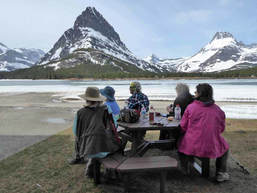 So much for 60 percent chance of rain: Not a drop of rain, just a few unsettled skies as we hiked the road into Many Glacier, ending in lunch with a view at the Many Glacier Lodge/Hotel. We took off from the District Offices at 6 a.m. and arrived at the trail head right at 9 a.m. The road was closed at Park Boundary, so that is where we started our hike. The snow on the peaks made the walk in eye candy all of the seven miles. One of the things about walking the road instead of driving or biking is that we stopped at each interpretive sign and hiked down to the Swift Current falls. None of us had done these items before as we are always in a hurry to get to our destination. Another thing we notices was painted V’s on the side of the road, each with an embossed nail at the tip. We surmised they must mark something such as culverts, wells, piping, electrical or surveying. According to the Department of Transportation website, they are survey markers for aerial mapping*. We also saw the repeater markers for the park service radios. All along the trail, we saw moose dropping and wolf and coyote scat, so we kept hoping to see some animals. Boy, did we see animals! We saw a goat, a herd of sheep, a yearling sheep right by the lodge and a yearling moose on our way out. Our lunch was filled with a bit of trepidation. One of the Xanterra workers drove over to us from the upper lot behind the lodge. He asked if we were hiking and to be careful as he had seen a bear in the upper lot headed down to the lake by us. Needless to say, we put the cans of bear spray in the middle of the picnic table just in case he wandered our way. He did not. And we had Catherine facing one way and Susan the other to keep watch. After a half hour lunch, we decided to risk it and headed to the upper lot to get the fantastic view over the Many Glacier Valley to view Mount Gould, Grinnell, Swiftcurrent, Wilbur, the Iceberg Notch and the B7 Pillar overlook the lake before the long trek out. This is where we saw the young yearling sheep, lying down by the stairs. Thankfully, we did not see the bear up close and personal, but we would have liked to see him from distance. Not many flowers were blooming, but we did see early buttercups and alyssum. The seven miles back seemed long, especially walking on pavement, so we moved to the shoulder to take some pressure off our feet and hips, but it was still a long seven miles with our back to the beauty and the interest of the interpretive signs gone. On the way in and at the lake, we saw no one else except the Xanterra worker. However, on the way out, we saw a group of three bikers from Browning, towing a baby, a lone hiker from Quebec who didn’t really know where he was going so we told him what to expect, and two other cyclists speeding by. Katie asked on cyclist about the road going through St Mary to Browning to round out the return trip with views into this lovely area. We arrived back at the cars just before 3:30 p.m. and headed to Dupuyer to eat at Buffalo Joe’s after a brief stop in Browning to stretch our legs and get a cool drink. We also visited the Cache, where Katie and Kuntzie both contributed to the local economy. By 8 p.m. we were at the District Offices, tired after a very rewarding day. (only a few sprinkles came down) *The symbols are ‘targets’ an aerial photograph; there is no meaning to different shapes or configurations of the markings (X, V, T etc). A survey crew is dispatched to survey the location of these targets and assign coordinates to each. When the survey is completed, the spatial relationship between each of the targets is known, such as the distance between them and the difference in elevation. This information is provided to an MDOT “photogrammetrist,” an aerial mapper. The photogrammetrist loads two aerial photos into a machine called a “stereoplotter.” Each pair of photos overlap each other so that each inch of roadway is photographed from two positions to create a 3D view. (Similar to toy stereo viewmasters where two photos are inserted in the viewmaster to make a 3D picture.) When the photogrammetrist views the targets in the 3D view, he can assign the coordinates given to him by the surveyor. Once this is complete, the relationship between the ground distances and the distances on the photo are known. Who went: Josy, Susan, Mary S, Kuntzie, Catherine, Katie |


 RSS Feed