Girls in Glacier | WELCOME
Like us on Facebook
  • Home
  • About
  • Calendar
  • Blog
  • Flowers/Trees
  • Helpers
  • Goodbye
  • HIkes
    • Hikes 2023
    • Hikes 2022
    • Hikes 2021
    • Hikes 2020
    • Hikes 2019
    • Hikes 2018
    • Hikes 2017
    • Hikes 2016
    • Hikes 2015
    • Hikes 2014
    • Hikes 2013
    • Hikes 2012

Crown Butte, Sept. 15, 2018

9/16/2018

0 Comments


Mary S. Finally Climbs Crown Butte

Picture
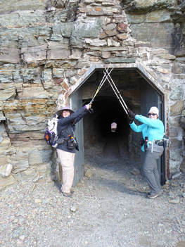
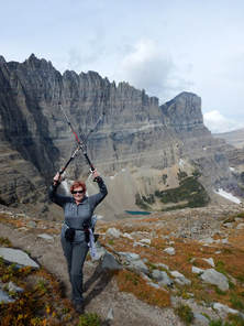
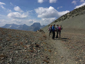
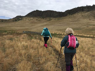
The GiG has climbed Crown Butte four times: 2012, 2013, 2014, 2015, but Mary S has never been able to make it. Plus we had at least three other trips planned, but the weather and gumbo roads prevented us from going.

So it almost seemed like a miracle when it didn't rain, the roads were good and we made it to the parking lot without incident We did have a few cows blocking the road (and a dead one to drive around), which Mary expertly navigated.

The weather was nice, very slight breeze, some clouds and haze from the smoldering fires. We made it to the top easily, enjoying some late flowers (showy and white asters, blazing star/gay feather, Canadian goldenrod. The fall colors were just starting, and currants plentiful.  Along the trail, we saw much bear scat with berries. We also saw one live and one dead mouse and a snake at the very end of the day. The snake coiled and made some noise, making us think it might be a rattler; but then we saw a pointed tail and knew it was just a bull snake, thankfully. 

We also saw hawks (or maybe harriers or falcons) and heard them. We even saw one try to make a meal of a magpie, but they all flew off cawing.
When we neared the top, we saw an abandoned bike. We were amazed at the athleticism the person must have to be able to bike up the steep trail. And since we didn't see any other car around, we knew the person must have pedaled the 7 or more miles of dirt road. We wondered who it might be. But we didn't find out. We saw no one on the top; the bike was still there when we left.

On top, we had a fun look-see around the rim, admiring the lime-green lichen, the spires of shonkinite with its black embedded augite crystals creating interesting formations on the edge of the butte.  We also wondered about the cracks in the rock that almost looked like they had mortar in them. In places, the spires looked man-made. We did find the Nature Conservancy sign on an overlook facing Square Butte.

We left GF at 10 a.m. and returned by 4 p.m. after a stop at the Mennonite deli.

Read more about Crown Butte here.
Visit Montana
Virtual field trip with geology (won't work on most mobile devices)
Who went: Karen, Mary S, Katie


Pix
Info from Nature Conservancy
​Crown Butte rises 900 feet above the foothill prairies just east of Montana’s Rocky Mountain Front. Fortified by tall columns of igneous rock and never cultivated or heavily grazed, the butte serves as an outstanding example of undisturbed native grassland.
Looking west towards the Front Range of the Rockies, wading through the robust native grasses atop the butte, the visitor feels transported in time to an era long before the first wagon train moved west across the prairie.

GeologyCrown Butte is a geological formation called a laccolith. It was formed by intrusions of molten rock, called dikes, which flowed between layers of shale and sandstone that were laid down as marine deposits nearly 80 million years ago. The weak overlying layers bulged upward as the molten rock (magma) intruded, creating the lens-like body of the laccolith. Some of the dikes are visible to the west of Crown Butte, and the soft underlying layers of shale and sandstone are seen at the mouth of the canyon to the south. 
After the magma cooled, it formed the resultant rock called shonkinite. Shonkinite is a distinctive rock that contains the glossy black mineral augite, which appears as small stubby crystals. Upon cooling, the rock contracted, causing vertical fractures that formed the towers and columns. While this weather-resistant rock still protects the underlying sedimentary rocks, the surrounding layers have eroded, exposing the butte.  
Laccoliths are rare formations, particularly ones with exposed dikes. Crown Butte is one of the finest examples of a laccolith in central Montana and most likely the world.

WildlifeAlthough the most striking features of Crown Butte are the rising columns of rock and the wild grasses, the preserve also provides a rich habitat for wildlife. Mule deer are often seen browsing on the summit or along the north slopes of the butte. The loud chants and trills of the rock wren can be heard from every outcrop on the butte. American kestrels, Cooper’s hawks, great horned owls, and prairie falcons hunt the butte, as do golden eagles.
The rocky remains of an “eagle catch” are found on the southeast corner of Crown Butte. Here, within the circle of stones which form the “catch,” native people would hide under branches that they had laid across the top. By placing meat or other bait on the branches they lured eagles to the “catch.” Once the eagles were lured, the natives reached up through the cover of branches and grabbed the legs of the great birds. The eagle’s feathers, considered to be sacred, were then used in clothing, head-dresses and ceremonies.
Vegetation Crown Butte offers an exceptional opportunity to encounter an undisturbed grassland ecosystem. The four main grassland habitat types are grouped according to dominant plant species. They are: 1) bluebunch wheatgrass/blue grama (on west-facing slopes and on the crest of small knolls); 2) rough fescue/bluebunch wheatgrass (on slightly more moist sites); 3) rough fescue/Idaho fescue (the most productive climax plant community on the butte); 4) Idaho fescue/bluebunch wheatgrass (found less frequently, usually on west-facing slopes, and includes needle-and-thread grass and thread-leaf sedge).

0 Comments

Ptarmigan Tunnel, Sept. 14, 2018

9/15/2018

1 Comment


Gail Crossed Ptarmigan Tunnel off Her Bucket List

Picture
We were off to make a dream come true for Gail: achieve the hike to Ptarmigan Tunnel.  For some reason, in all of the years of GiG, she had never done this hike. The weather looked good, and the Park Service had just reopened the trail after more than a month of closures due to bears.

The day started off at 5:15 a.m. and took us through fog, lot of it, slowing us down as we drove around Duck Lake, amaking us worried that we would have a bad day of hiking despite the "mostly sunny" predictions. As we started the trail, we noticed the path to the Many Glacier Hotel was closed with a Danger-Due-to-Bears sign. We realized that the bears must have moved over just slightly; all day long we saw piles of bear scat on the trail, full of currants and berries.

We did have fog for the first part of the hike; however, we had beautiful glimpses of snow-dusted Mount Wilbur, Gould and Grinnell, that got hit with the white stuff the night before.  The trail had a few puddles to prove that the weather had come and gone, too.

But what really impressed and wowed us were the fall colors: reds of the huckleberries and fireweed, salmons of the spiraea, oranges of the currents, yellows of the silverberry, aspen and thimbleberry. The brightness almost hurt our eyes. And we couldn't stop taking photos, which probably cost a half an hour of time, but who cares? 

Another surprise was that some of the trees around Ptarmigan Falls must have fallen down as we could get a full view of this before-hidden cascade.

As we took the turn toward Ptarmigan Lake, the trail took an uphill slant, but we kept moving and pretty quickly. The wind started coming up as well, chilling us. Just before we got to the lake, we heard a large animal walking around and hitting rocks in the creek below us; however, the willows and other brush was too thick for us to see. We imagined it was a moose due to the willows. A little later we heard what sounded like gunshots and some rocks falling from the mountainside to our right. From past experience, we knew that bighorn sheep were in the cliffs butting heads, but alas, we couldn't see them even though we looked and listen for a bit. We wondered if what we heard before was sheep crossing the creek before heading up the hillside.

At the lake, we took a very short break, grabbing a quick lunch and putting on more layers. Then we had to remind Gail about Susan's advice: do not look up.  At this point, it is easy to get discouraged, look up at the switchbacks through the scree and give up.  But we weren't going to let that happen. We were going to make it no matter how long it took, so slowly, slowly we did just that. It took about 50 minutes from the lake to the tunnel. We took a few pictures at the overlook and in front of the tunnel before heading through it.

And the views! Wow, we had fantastic sights into Lake Elizabeth and the Belly River country. Most of the hikers we met going down as we headed up said they were unable to see the lake due to fog and clouds, but by the time we got there, the clouds had lifted. We commented that sometimes there is a benefit for taking your time.  

Then we went a bit further down the trail so that we could see Old Sun Glacier, one of the few that isn't melting rapidly and in some years actually grows a bit. It sits higher than the others at 8,200 feet and has a mostly northern exposure, further protecting it. Read more

​
We admired the striated rock and the lime-green lichen clinging to it, before heading back through the tunnel to descend. On our descent, the colors were still popping, even a bit more, since the sun had poked its head out of the clouds. The underbrush on the side of Grinnell Point really stood out.

At the parking lot, we saw three huge, silver-backed grizzlies above the trail--luckily they were quite far off. Several people had spotting scopes to get an up-close look at them. 

We had a nice early dinner (4:40) at the Swiftcurrent Inn before heading back home. On the way, we saw one black bear and four more grizzlies. We arrived in Great Falls around 9:15
Who went: Gail and Katie

Pix
1 Comment

Piegan Pass, Sept. 11, 2018

9/12/2018

0 Comments


Pretty Rock Turns into Surprise Find on Piegan Pass

Picture
This day held a surprise along the way, which would unfold  once the gals attained the top of the Piegan Pass.

Three gals, all of whom had never taken this path before, decided to give this  nine-mile hike with just under 2,000 feet of gain, a try, planning for a slow pace if necessary. Two others had really wanted to do this hike, but weren't able to make it. They sure missed a nice one.

With all three of us having never done this hike before, we decided to play it safe and start really early as the days are rather short in September.  We left Great Falls at 5:30 a.m. and got on trail at just before 9 a.m. We had no trouble parking in the small lot at Siyeh Bend as we were the first ones there.

At this time of day, it was quite chilly. In fact, it was so chilly that normally on-fire Susan even put on a jacket, much to the other two gals' amazement. But in not time, we were shedding layers as the uphill starts out right away.

The hike itself was beautiful. Preston Park and other sections of the trail still had flowers, mostly asters, pearly everlasting and Indian paintbrush, sticking out among the fall colors of the underbrush. The berries really shined too: elderberries, black twinberries, mountain ash.

In general, we had the park to ourselves, seeing only about 20 people on the trail and most of them were heading to Siyeh Pass, so we lost them at the fork.  We did come across some hikers at the top of the pass who had come up from the Many Glacier side, having done the hike the hard way with 4,000 feet of gain and only 2,000 feet of loss.

We ate lunch at the top of the pass and didn't see any of the pesky marmots that can harass hungry hikers.

On top, June went off trail exploring a bit when she found what looked like a very pretty, but very uniform-in-shape, rock.  When she picked it up and turned it over, she saw it was a small stone plaque that had a name, number and date on it. We weren't sure where it had come from and surmised maybe it was on top of the mountain and had come done in a rock slide. It read: "Forever Loved, #4014 Mark S. Williams, 2017." It appeared someone may have scattered ashes or just wanted a remembrance of a loved one placed on the pass for some reason, perhaps it was one of his favorite hikes. We wondered what the #4014 meant.  Gail did some sleuthing and found a reference to a Mark Williams dying in 2017 with reference to the same number, but still the number is a mystery for its meaning.  We left the rock plaque where we found it. See photo slideshow below and this link.

We didn't see much for animals, except one sheep that was lying down both coming and going.  We surprised ourselves by finishing the hike at 3:30, about an hour earlier than expected, but the weather had been perfect, not too hot, enabling us to really make good time.

On the way home, we stopped at a couple places to eat but they were all closed, so we just headed home. We arrived back in Great Falls at 7:30 p.m.. 

Who went: June, Gail, Susan W.

Gail's Pix
Picture
0 Comments

Firebrand Pass, Sept. 8, 2018

9/9/2018

0 Comments


Fall Colors and Wind Blew Us , Canadians Away on Firebrand Pass

Picture
Bright red fireweed, hot orange mountain ash, snow berries, saskatoons/service berries and a few hucks--These provided a wonderful understory as we sauntered through thigh-high brush and gorgeous aspen groves before we broke out into the alpine section of the Firebrand Pass hike with our Canadian sister group, the WoW (Women of Wonder).

The day started and ended with a train blocking our way, making us wait to get over the tracks to the trailhead for this little-used southern-part-of the-park hike. Even though it is not very popular, about 20 cars were parked at the end of the day. Most of the activity was probably due to the west-side fires shutting down all of the trails, forcing everyone to the south and east side.

Six Americans (five from Great Falls and one from Eureka joined seven gals from Alberta, Canada. We got on trail at 9:30 a.m. behind six other parties who got an earlier start.

As we made our way on the flatter part of the path, we marveled at the fall colors: the oranges, yellows, lime green and red ground cover really popped in the sun. We knew autumn had started when we saw the false hellebore drooping and brown from an early frost and August snow.  Contrasting with the fall colors, we also were happy to see blue sky instead of the smoke we have been used to for over a month. With predictions of 48 miles-per-hour winds, we were surprised that we didn't even feel a breeze--yet.

When we hit the alpine section, we felt a breeze and knew the scree section could be challenging if a big gust came where the drop offs were at a dangerous angle; but luckily, the wind kept mostly to our backs and didn't present any issues.

However, on top of the pass, the wind was gale-force. We had a hard time keeping on our feet. After enjoying the views of Mount Despair, Peak 8888, Summit and Little Dog and taking a few pictures, we scooted down the side of the pass behind some trees and bushes to get out of the wind before eating our lunch. 

Then we headed down and retraced our steps, leaving the side trip to Lena Lake for another day. On the way back, we came across several parties just getting started, including a tour of about 30 people, including some Asians who didn't appear to be properly dressed for such a trip.

Interestingly, we didn't see any animals: none of the usual bighorn sheep or marmots showed their faces, but it could have been the wind. A few of us did hear the whistle pigs (marmots) calling to one another. Some thought they heard pika too. However, we did find a green shieldback Katydid, sometimes called a Mormon cricket.
​
We arrived back at our cars around 4 p.m. and headed to East Glacier for a meal at Serrano's but not before getting in a little shopping at Glacier Park Lodge gift store, the pottery shop and the Old Goat Traders.
​
After dinner, we drove home arriving back in Great Falls at 8:15 p.m. 

Who went: Americans: Madelon, Susan C, Anita, Mary S, Beth, Katie; Canadians: Laura, Marilee, LaVern, Dina, Joan, Shellee, Lorna

Pix
0 Comments

O'Brien Creek, Sept. 1, 2018

9/2/2018

2 Comments


O'Brien Obstacle Course: Bushwhacking, Stream Crossings, Deadfall 

Picture
es, we hiked the O'Brien ski trail, not knowing what to expect without the cover of snow. We did get a surprise or two along the way in the form of bushwhacking through willows, rock-hopping at stream crossings, climbing over and under deadfall and slogging through mucky springs. 

We left Great Falls at 7:15 a.m. and got on trail at 8:45 a.m. after dropping a car in Neihart and a bathroom stop at Silver Crest. At the top of Kings Hill Pass, we were surprised to see all of the rigs with trailers, but then we remembered it was the start of bow season. Frustrating us, the hunters had parked sideways, blocking all of the spots, so we had to park across the highway. 

The hike starts straightforward enough, following the cat track of the snow machines to the edge of the Golden Goose ski run. Then it takes a turn from Showdown and continues through the lodgepole pines until it hits the open area of O'Brien Park: so far so good. The trail was very easy to follow without many obstacles until this point. And the blue diamonds were plentiful as well, clearly marking the way. During this part of the hike, we followed a bow hunter, dressed in camouflage. We figured he was really thrilled to have us yakking and laughing, scaring all of the elk away.

After we crossed the service road by O'Brien Park, the going started to get rough. At this point, the trail follows a drainage with many rocks in it, real ankle twisters.  To avoid the rocks, we often found ourselves in tall brush which disguised holes left by elk hooves and burrowing animals. We saw many piles of elk droppings and matted areas where the herds had slept.

This drainage then ends where it enters O'Brien Creek, the start of our bushwhacking portion of the adventure. The rest of the day we were searching for the few blue diamonds (some of which were new and of a royal blue color instead of the traditional aqua and much harder to see, we found), in hopes that they would aid us in finding a way out of the marshy mess of willows. 

Several times we tried to go higher on the sidehills to avoid the muck. However, there were many springs oozing out, which created a bog too. Our boots sunk down. At times, it was easier to step on the willow branches to help stay atop of mud.
Another obstacle we found when we went high on the hillsides was deadfall: hundreds of trees littered the forest floor. The going was very slow at these places.

We also faced about 15 stream crossings; a few of us fell in at various times as we used downed logs and rocks to avoid wading. We all brought water shoes/sandals, but we never did change. Some of us probably would do so next time.

The trail was pretty despite the obstacles with deep greens along the creek, with even a few late blooming flowers: purple showy asters and harebells, deep orange paintbrush, fringed grass of Parnassus, yellow and pink monkey flowers, Shasta daisies, to name a few.

We were also fascinated with all of the green-lichened rocks  that had tumbled down the mountains, producing enormous talus fields. In several places, the steep rock walls created beautiful canyon. And we came across the old homestead, that is fast disappearing--in the snow, only a few logs are apparent; however, we saw some old kitchen items including a washbasin.

Despite the pluses, we all said we weren't eager to hike O'Brien Creek again any time soon. We were happy we did do it, but it wasn't the easiest trail to follow in summer. It is a much better ski (but most felt trying to snowshoe this route would be over the top--a very long day indeed)

The trip took us six hours to cover 8.5 miles, a long time due to all of the difficulties along the trail along with route finding. Then four of us walked the extra mile to Bob's bar while the others shuttled to get the two cars at the top of Kings Hill.

After a late lunch (3-4 p.m) at Bob's, we arrived home at 5:15 p.m. On a side note, Tony at Bob's Bar said he has an offer on his business. If he does sell, the new owners will take over by Christmas. And he wants us to stop by his house after he leaves. However, he may have to move as the new owners are from Texas and as of yet can't find a house that is acceptable. They may want to buy his house as part of the deal. We were all saddened by this news.

Who went: Karen, Anita, Susan C, Katie, Gail, Jeanne, Susan W, Sara, Catherine

Katie's Pix
2 Comments
    How to Download Pix
    ​How to download with iphone, it's easier with OneDrive app
    ​Hikes by Year
    ​Pictures

    Archives

    October 2021
    September 2021
    August 2021
    July 2021
    June 2021
    May 2021
    April 2021
    March 2021
    February 2021
    January 2021
    December 2020
    November 2020
    October 2020
    September 2020
    August 2020
    July 2020
    June 2020
    May 2020
    March 2020
    February 2020
    January 2020
    December 2019
    November 2019
    October 2019
    September 2019
    August 2019
    July 2019
    June 2019
    May 2019
    April 2019
    March 2019
    February 2019
    January 2019
    December 2018
    November 2018
    October 2018
    September 2018
    August 2018
    July 2018
    June 2018
    May 2018
    April 2018
    March 2018
    January 2018
    December 2017
    November 2017
    October 2017
    August 2017
    July 2017
    June 2017
    May 2017
    April 2017
    March 2017
    February 2017
    January 2017
    December 2016
    November 2016
    October 2016
    August 2016
    July 2016
    June 2016
    May 2016
    April 2016
    March 2016
    February 2016
    January 2016
    December 2015
    November 2015
    October 2015
    September 2015
    August 2015
    July 2015
    June 2015
    May 2015
    April 2015
    March 2015
    February 2015
    January 2015
    December 2014
    November 2014
    October 2014
    September 2014
    August 2014
    July 2014
    June 2014
    May 2014
    April 2014
    March 2014
    February 2014
    January 2014

    RSS Feed

    Girls in Glacier and Katie Kotynski

Contact Us
Copyright 2014-2022 Girls in Glacier
All pictures copyright of individual photographers; no use granted without permission