Day of Chaos and Mayhem Sees Several Gals Reach Personal Bests
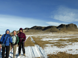
 With names like Chaos and Mayhem, the trails along the south shore of the Missouri sounded like too much to handle. But if you are hiking, rather than biking, then the walk is fairly tame, if long. One sign warns of "dangerous cliffs," and these cliffs do contain quite the drop-offs; but when hiking, it is easy to stay away from the edges. These trails are much preferred over the higher old road, even though they wind in and out of the river cuts and coulees because you see the river the whole way, creating gorgeous landscape views. And much of the land is untouched; and if it weren't for the power lines and dams, it would look much the same as Lewis and Clark found it. The day started at 8:45, under a blue sky with a breeze to our back.We admired the new generating station with its powerful turbines, creating clean energy. However, the new Rainbow Dam station does divert most of the river for a quarter-mile stretch, leaving the main channel as well as Crooked Falls mostly dry. When one looks at the rock ledge of Crooked Falls, it is hard to imaging water pouring over the entire ridge as it used to do. After Crooked Falls, one mile in, our first stop was Whitmore Ravine, where we stopped to read the interpretive sign about the destruction of the habitat caused by local farmers and Malmstom air force base's storm drains and other run off water. The silt from the run-off is basically damming up the Missouri. From here, we walked another three miles to Cochrane Dam, at which point we stopped for a snack just before 11 a.m. We sat on an overhang overlooking the dam and the trickle of water flowing over at this time of year. This dam and Morony are the two of five dams in this area that do not have waterfalls associated with them. Cochrane also isn't a major electric-generating dam. Cochrane was named for a hydroelectical engineer for Montana Power Company. The dam was the last one built on this stretch of the Missouri, completed in 1958. After our snack, the clouds started rolling in, and the wind picked up a bit. Another couple miles down the trail, we came to Ryan Dam and the Great Falls of the Missouri for which the town is named. This dam is much more scenic, forming a semi-circle above the Falls.It is also the largest of the five dams. It was first named Volta, but then renamed for John Ryan, the head of both Anaconda Co and Montana Power. In addition, people can drive to the north-shore side to visit the tailrace Island, which is open May-September for picnics and other events. It has a nice covered picnic area and a kitchen. It is fun to look down on the people visiting the island from the high perch you have when hiking on the south shore. More here. More information on all of the dams and when they were built is on the right-hand sidebar, except it hasn't been updated to include the new Rainbow Dam output of 62 megawatts, making it number-one in electrical production with Ryan Dam a close second at 60.. After taking pictures of the dam and island, we settled into a coulee to get out of the wind for lunch. We marveled at all of the wood in Ryan Dam, so unlike the cement structures of the others. After lunch, we took the easier way home, abandoning Mayhem and Chaos, listed at the most difficulty ways, to stay on an old road, now turned trail. It was still a lot of ups and downs, with more ups on the way home. We realized just how much the Missouri drops with all of the waterfalls along this stretch. the Missouri River drops 551 feet in just over 22 river miles from the Upper Portage of Lewis and Clark, located near the Ayrshire Dairy, south of Great Falls, to the Lower Portage one mile downstream from the mouth of Belt Creek, past Ryan Dam, In comparison, The Mississippi drops only 400 feet in 1,200 river miles from St. Louis to the Gulf of Mexico, so yes, we did face uphill. On our return trip, we were up higher and didn't have much for views of the river until we hit Crooked Falls. By this time, everyone was getting a bit tired and took a break before we headed up the last hill to the parking lot. The gals with fit bits reported 32,000 steps and over 13 miles. Along the way, we scared up a herd of mule deer and in another coulee, saw a buck chasing a doe. He was very intent on her and ignored us for the most part. We also saw geese, mallards a hawk and seagulls as well as one rabbit. We also saw some flowers blooming, a rarity for this time of year: groundsel, harebell, salsify and dandelions. Who went: Gail, Susan, Sue O., Nancy C., Cathy, Kathy D., Anita, Michelle, Katie |
 RSS Feed