Susan Climbs 20th Peak on Mount Otis Hike; Snow Surprises Us
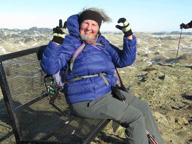 Susan at the top of Mount Otis, her 20th of the year. Susan at the top of Mount Otis, her 20th of the year. It was a day for turnarounds, a day of check points, a day of gusts, a day for snowy trails and cow pies, and a day for Susan to reach her 20th peak in 2020! We left Great Falls at 7:45 a.m. to head across the Rocky Boy Reservation to Beaver Creek Park. We had two checkpoints to cross, having to give our name for COVID-19 contact-tracing purposes, just in case. We also were told not to stop on the reservation for any reason, which we already knew. As we drove across the reservation, we noticed quite a bit of snow on the ground and wondered if we should have brought snowshoes; too late now, we thought. At about 10 a.m., we arrived at the park, at the Bearpaw Lake section to hike a loop trail. Rising from the foothills and nestled in the Bears Paw Mountains, south of Havre, the Park covers over 10,000 acres and 17 miles along highway 234: the Beaver Creek Highway. Established in 1916, it is the largest county park in the United States. Normally, it costs $10 per person per day to recreate at the park; however, Tom read at the drop box that there was no charge for day use right now, probably due to COVID-19. As a side note, one of the gals had given her $10 to one of the checkpoint workers. Who knows what they thought about being handed $10.On another side note: Tom and Katie turned the wrong way to begin with, necessitating everyone to turn around. This happened twice more on the way home! We all know our turning radii of our cars now. The road over the dam, where one would normally drive to the parking area, was drifted over with snow, so we parked and walked over the dam instead, being careful not to slip on the ice. Luckily, there is an outhouse, so we all used it while contemplating which way to start hiking the Rotary Canyon Loop trail. Tom and Mike, Katie and Camille's husbands, would hike the opposite direction of the gals. The two guys started out, while we all waited for the bathroom, but they quickly lost the trail, so turned around and decided they would go the other way. While this hike ended up in a bit of a bust since we got snowed out quickly, we went around the icy sections by gaining a ridge with wonderful views over the lake and the surrounding mountains, so all was not lost. Gail and Jo Ann gave up earlier and had already driven away by the time we did a small circle back to the cars. Then we backtracked, driving the highway to the Mount Otis trailhead; however, the road into the parking area was very snowpacked and icy. Beth braved it a bit but the rest of us turned around-- again--and parked along the Nature Trail roadway, deciding we would hike off trail and attack the mountain from the west instead of walking around to the south where the trail lay about a mile down the road. Going this way was very steep, but only one mile, so we all made it easily, if slowly, especially in the wind. Gusts hit us head on at times, knocking us down or making us dig our poles in for purchase. One interesting find was a blooming and budding flower: a phlox! The top was worse for wind, coming from all sides it seemed. We all let Susan get to the top first with the rest of us cheering her on. On top is a bench, which our lady of the hour quickly sat in like a queen, forming a number 2 and a 0 with her fingers for a pictures. After a group shot, we scurried down, deciding to take the trail and walking the road back. The trail is gentle switchbacks, but several curves were drifted with snow, forcing us off trail for skirting the icy; otherwise, the trip down was uneventful until Amber slipped at the end, right where a field of cow pies lay. She narrowly missed disaster. The road walk was a combination of ice, snow, mud and cow pies, so the cars were a welcome sight. We drove back across Rocky Boy to Box Elder, going though the checkpoints again, and back home. We arrived home around 4:30, before dark. Who went: Susan, Camille, Amber, Beth, Suzie, Carol, Katie in one group and Jo Ann and Gail in another, . |
 RSS Feed